The Storm Prediction Center has upgraded our forecast area to a level 4 Moderate Risk for severe weather. All modes of severe weather will be possible, including a significant tornado threat. A Tornado Watch has already been posted for much of the forecast area. An eroding cap will give way to significant lift from an approaching dryline and large storm system lifting northeast onto the Central Plains from the Desert Southwest. Storms are already forming off the dryline and moving eastward just east of Abilene. A very moist atmosphere is in place across the area. There is 3000 to 4000 J/Kg for convective available potential energy (quite high) and moderate wind shear on the order of 300 M2/S2. Of real concern is backing surface winds across the area. All these parameters point to supercellular storm mode with any storm capable of producing large and strong tornadoes and giant sized hail up to softball/grapefruit size. In addition, heavy rainfall will be possible and some of the tornadoes could become rain wrapped and difficult to see. Residents of DFW should pay close attention to the changing weather conditions, and please take seriously any Tornado Warning issued for your area by taking appropriate action. Remember the best place to go is to an interior room, without windows, on the lowest level of the building or home.
Tag Archives: hail
FIRST SEVERE WEATHER SETUP OF THE SEASON TODAY AND TOMORROW

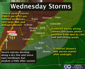
Severe weather setup for Wednesday afternoon into Wednesday night. Graphic courtesy of the National Weather Service office in Fort Worth, Texas.
UPDATE: The latest data is now suggesting that the CAP will hold strong over the forecast area greatly reducing any threat of severe storms over the immediate Metroplex. This is in part because a lead short wave is now expected to move across the area earlier today, around midday, with subsidence in its wake during peak heating hours. Thus, for the CAP to break, we must await the primary shortwave expected later this evening well after peak heating when instability will be much less. Still there is a chance of thunderstorms this evening, mainly elevated, with the primary shortwave and again with the passage of moderately strong cold front. Much cooler tomorrow with overnight lows Thursday night into Friday morning falling into the upper 30s to mid 40s across the area.
The first significant severe weather event of the season is taking shape across North Texas today, but especially tomorrow.
For today, a shortwave will track across the Central Plains sending a weak cold front into North Texas this afternoon. The main dynamics with this system appear to be too far removed from North Texas to be strong enough to break a strong capping inversion aloft. However, with the weak frontal boundary in place across North Texas, mesoscale forcing and frontogenesis combined with strong compressional warming may be just enough to weaken or break the cap along and east of a line from Weatherford to Gainseville and north of the I-20 corridor. As a result, have placed 20% POPs for isolated convection that could initiate in this region. As you approach the Red River into Oklahoma, convective inhibition becomes almost negligible and a much higher chance for convection exists. Temperatures are expected to rise well into the 80s, even the upper 80s to around 90 in some places due to the compressional warming from the front. This heating could be strong enough to lift the cap. Combine this with steep lapse rates, very cold air aloft, and CAPE approaching 2000 J/Kg, any storm that is able to get going will become severe and supercellular in structure with the potential of producing very large hail and damaging winds. With the wind fields rather weak in the lower levels, I expect the tornado threat today to be rather low, but non-zero. I am not expecting a widespread severe weather outbreak today in our area, but there is an isolated risk should convection be able to initiate. In all likelihood, the CAP will hold.
For tomorrow (please see graphic above), a much different scenario will play out. Another shortwave will eject onto the Plains, much further south than today’s. As a result, a surface low will develop near Wichita Falls with a dryline extending perpendicular south/southwest to the low and a cold front off to the north/northeast forming a triple point. This will increase surface winds across North Texas tomorrow. Most of the forecast area will be strongly capped, but as the dryline approaches a line from Comanche to Mineral Wells to Gainseville, the cap will begin to lift and convection should fire along the dryline. Across this area, CAPE will again reach 2000 J/Kg with strongly sheared low level winds. Thus, convection will rapidly become severe with the threat of very large hail, damaging winds, and tornadoes. The storms will be supercellular in structure and discrete initially, but will begin to organize into a squall line as the dryline marches eastward. Across the immediate DFW Metroplex, I expect the capping inversion to hold and cause approaching surface-based convection to be become elevated over the cap as the storms approach the I-35 corridor. This will greatly reduce the tornado threat here, but large hail and damaging winds will still be a threat as 1000 to 1500 J/Kg of CAPE will still be available across our area. Should the cap lift across the Metroplex, then the severe weather threat will increase with tornadoes possible.
