
November 2025 has been nothing short of historic in Dallas/Fort Worth. Temperatures have soared to very warm levels, cementing it as the hottest November on record thus far. Several daily temperature records have been broken. But if history is any guide, this kind of extreme warmth rarely lasts. In fact, some of the hottest Novembers in DFW history have been followed by some of the coldest Decembers.
Lessons from the Past
- 1909: Severely cold December that followed a very warm November. Also a La Niña winter with similar setup to 2025.
- 1917: Very cold December that was also a La Niña winter that has similar setup to this year that followed a warm November.
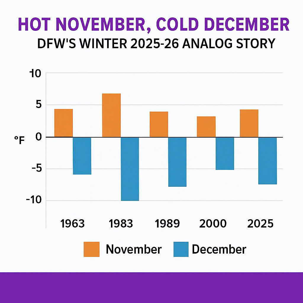
- 1963: November was unusually warm, but December flipped dramatically. Arctic outbreaks brought extended freezes and snow events across Texas.
- 1983: A warm November gave way to the coldest December ever recorded in DFW. The city endured 295 consecutive hours below freezing, with temperatures averaging nearly 12°F below normal.
- 1989: A textbook flip—November ran above normal, but December plunged to -9.1°F, delivering DFW’s third coldest temperature on record at -1°F on December 23.
- 2000: Another warm November preceded the third coldest December on record. Arctic air dominated, and snow fell across much of Texas.
Why the Flip Happens
The atmosphere often seeks balance after extreme anomalies. When November runs hot, December can swing the other way — especially when the large‑scale teleconnections line up. Right now, they do:
Key Current Teleconnection Signals (Late November 2025)
- Negative PNA: Western troughing favors downstream ridging into the Southeast, opening the door for cold delivery into the Plains.
- Negative WPO/EPO: High-latitude blocking near Alaska and the Bering Sea reinforces Arctic air displacement.
- Negative NAO/AO: Greenland blocking and polar pressure anomalies support meridional flow and cold intrusions.
- MJO Phases 7–8–1: Tropical forcing is entering cold-favorable phases, historically linked to high-latitude blocking and U.S. cold outbreaks 10–20 days later.
- Stratospheric Warming: A major SSW event is unfolding unusually early, disrupting the polar vortex and increasing the risk of Arctic air spilling southward.
What It Means for December 2025
With November 2025 running hottest on record, the analogs and current teleconnections strongly suggest a high risk of a cold flip. The setup resembles 1963, 1983, and 2000 — years when Texas endured some of its most memorable Arctic outbreaks. December may not be a wall‑to‑wall freeze, but the risk of sharp cold shots is elevated. Expect volatility: warm interludes punctuated by strong Arctic fronts, especially mid-to-late month.
Bottom line: November’s record heat is not sustainable. With the NAO, PNA, WPO, AO, and EPO all trending negative, the Arctic door is opening. History tells us that when DFW runs hottest in November, December can deliver some very cold air. Winter 2025–26 may be setting up to follow that script. Time will tell if the cold comes and if it lasts into much of the winter or retreats. Keep in mind that this is not a forecast, just something that we are monitoring.