DFW has already recorded 7.16 inches of rain this June — placing 2026 among the top 10 wettest Junes on record. Only eight other years have been wetter up to this point: 1928, 1935, 1940, 1981, 1989, 2004, 2007, and 2017.
What makes these years so interesting is not just the rainfall — it’s what happened afterward. Across more than a century of climate data, a very wet June in North Texas is one of the strongest predictors of a cooler‑than‑normal summer with far fewer 100‑degree days.
And the consistency is remarkable.
Why Wet Junes Matter
When June rainfall is excessive:
- Soils become saturated
- Evapotranspiration skyrockets
- The boundary layer stays humid
- Extreme temperatures are suppressed
- The summer ridge struggles to anchor over Texas
This combination has historically produced summers that are cooler, cloudier, and far less extreme than the typical DFW scorchers.
The 8 Wetter‑Than‑2026 Junes — And What Followed
Below is the expanded dataset showing:
- ENSO state the winter before the wet June
- ENSO state the following winter
- Whether the summer was below normal
- Total number of 100‑degree days
This is the heart of the pattern.
📊 Expanded Analog Table
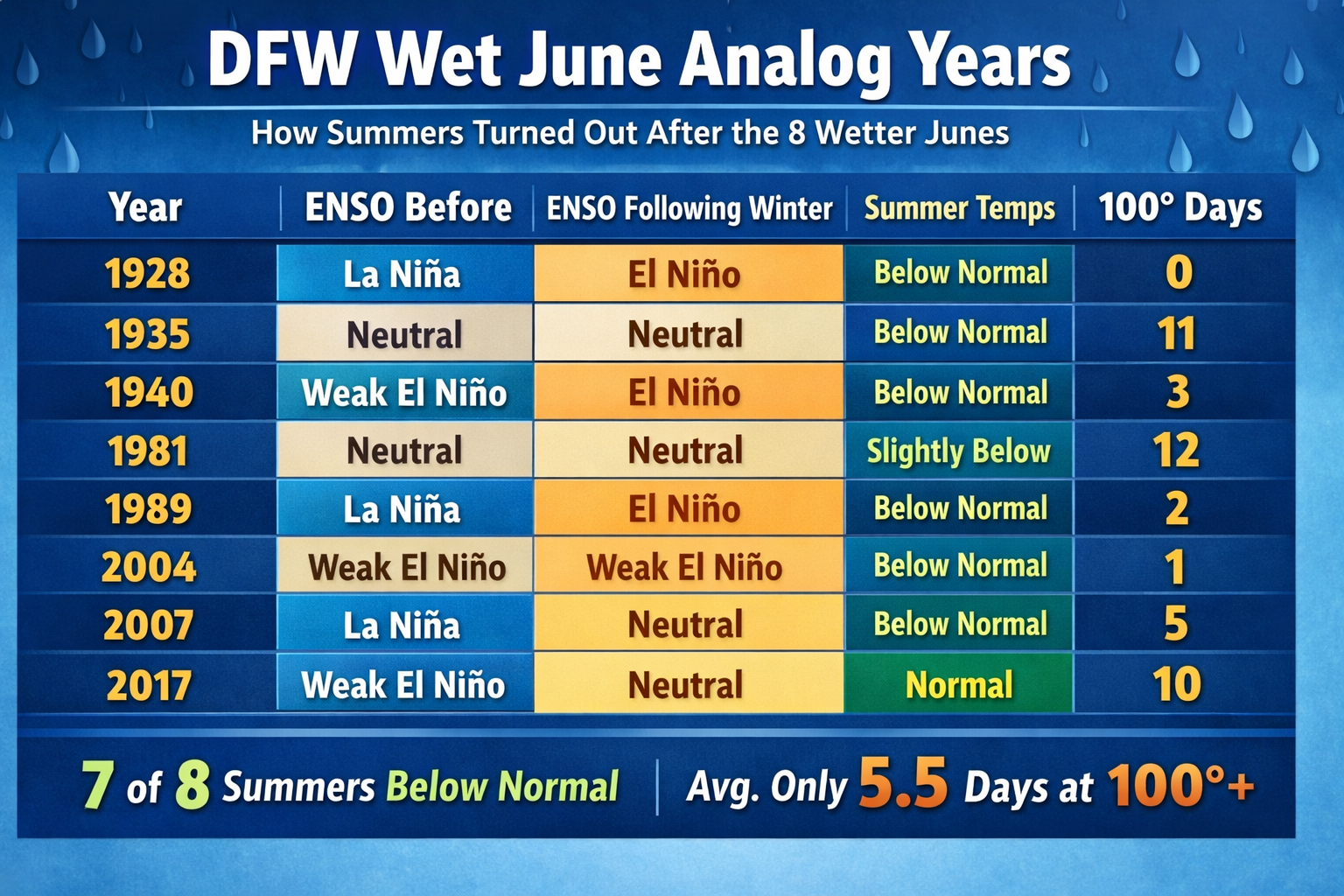
What the Analog Years Tell Us
Across these eight years:
- 7 of 8 summers were below normal
- 100° days averaged only 5.5 per year
- Only one year (2017) reached “normal” heat
- None produced a hot summer
- La Niña → El Niño transition years (1928, 1989, 2007) were especially cool
This is an extraordinarily tight cluster.
Where 2026 Fits
2026 is currently:
- Coming off a La Niña winter
- Sitting in neutral ENSO
- With a weak El Niño possible this coming winter
- Carrying very high soil moisture
- Tracking rainfall similar to 1928, 1989, and 2007
Those three analogs had:
- 0, 2, and 5 triple‑digit days
- All cool summers
- All ENSO flips to El Niño
This is why the probability of a cooler‑than‑normal summer with 10 or fewer 100° days is legitimately high, based on the historical dataset.
Bottom Line
When June is extremely wet in North Texas, the summer almost never turns hot. The atmosphere simply can’t overcome the soil moisture, humidity, and disrupted ridge pattern.
With 2026 already in the top tier of wet Junes — and matching the ENSO transition years most strongly associated with cool summers — the historical odds overwhelmingly favor:
- A below‑normal summer
- A delayed first 100° day
- A total of 3–10 triple‑digit days
In other words: A rare break from the Texas heat looks likely.