
A very wet week is in store for our forecast area. A powerful upper-level storm system is currently setting up shop out in the desert southwest and will become a cut-off low taking its sweet time to move eastward this week. As a result, several rounds of showers and thunderstorms will be possible across the area beginning early tomorrow morning and lasting through much of next week into next weekend. Very heavy rainfall can be expected, especially tomorrow into Tuesday, as precipitable water values (PWATs) climb to 1.45 inches around the 75th percentile for April. There is an attended severe weather risk tomorrow into tomorrow night, but most of the severe weather should stay south of I-20 into Central Texas. The main threats will be large hail and damaging winds in addition to flooding. The tornado risk will be highest the further south you go, but not zero in our neck of the woods. The big story will certainly be the amount of rainfall. A Flash Flood Watch has already been issued by the National Weather Service office in Fort Worth for the entire forecast area for widespread 4 to 6 inches of rainfall with sporadic amounts to 8 inches plus by Tuesday morning. Residents of North Texas should begin making preparations for flooding conditions. Remember not to drive across water covered roadways.
Tag Archives: heavy rain
HEAVY RAIN EXPECTED TOMORROW INTO SUNDAY
As discussed yesterday, we are still expecting a heavy rain event to affect the area beginning tonight and lasting into Sunday. A Flash Flood Watch has already been issued for the entire forecast area by the National Weather Service office in Fort Worth. The graphic below depicts what we can expect in terms of rain amounts by the end of this event. On average, 3 to 6 inches of rain is expected across our area with locally higher amounts possible. This will only exacerbate the extraordinary rainfall received this year and flooding and flash flooding will be of major concern.
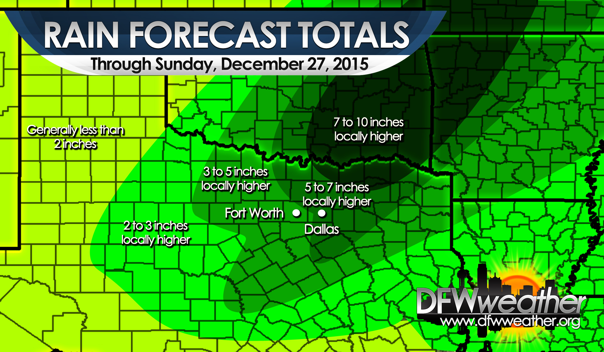
Post Christmas 2015 heavy rain event. Map depicts expected rain totals by the end of the event.
MAJOR RAIN EVENT TODAY TO SUNDAY [UPDATED]
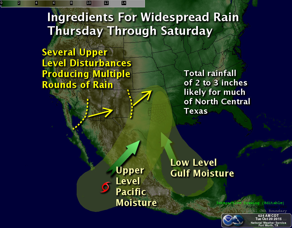
Setup for major rain event unfolding for DFW for Thursday through Sunday. Map courtesy of the National Weather Service, Fort Worth, Texas.
UPDATE: It appears that everything is lined up for two episodes of heavy rain, one tonight into tomorrow, and another tomorrow night into much of Saturday. Forecast rain amounts, when all said and done, will be a widespread 3 to 6 inches of rain across the forecast area with isolated amounts approaching, or even exceeding, 10 inches. It is too hard to determine where the heavier, narrow bands of really intense rainfall will setup, or what areas will see the most training of storms, but these are the areas that will receive the most amounts of rain. A Flash Flood Watch has already been hoisted by the National Weather Service office in Fort Worth that includes all counties covered by this website. Please stay alert to changing weather conditions, and remember, don’t drive your car into flooded roadways.
It has been quite some time since DFW recorded multi-inch rains or had a protracted rain event, but it appears the ingredients are coming together for a major, protracted rain event later this week. An upper-level low is going to slowly eject east northeast from the desert southwest onto the plains. As it does so, tropical moisture gathering near the Yucatan (was once projected to form into a tropical system by the models, now will not) will be advecting northward into North Texas. In addition, what will be a named storm, Patricia in the Pacific, her remnants and moisture will get absorbed northward into Texas this weekend allowing pWATS to climb to 2 inches, a good two standard deviations above normal for October. Another disturbance will quickly move in on the heels of the desert southwest upper-low dragging a cold front with it providing additional lift Saturday and Sunday. All this points to a heavy, protracted rain event beginning as early as Thursday and lasting through Sunday for the forecast area. It is too early to nail down just how much rain we will receive, but indications are that this will be a widespread multi-inch rain event for the area.
DFW TO SEE VERY HEAVY RAINFALL AS TROPICAL STORM BILL MOVES OVER THE AREA
Tropical Storm Bill is bearing down on the Texas coast this morning near Matagorda Bay. Tropical Storm Warnings are now in effect along the Texas coast. Tropical Storm Bill is currently located as of 7:00 am at 28.2N latitude and 96.0W longitude with maximum sustained winds of 60 mph and a central pressure of 997 mb. It is heading to the northwest at approximately 13 mph. Most model guidance then turn this north toward the DFW Metroplex. The heaviest rains will be to the east or right of the center of circulation as it moves north and eventually northeastward. The latest guidance is unanimously coming into agreement that it will track along the I-35 corridor or just to its west. This puts most of the DFW Metroplex in a position to see heavy rainfall beginning as early as Tuesday evening and lasting through Thursday night. In addition, most of the Metroplex will be in the favorable quadrant to see tropical tornadoes. Obviously with the record rains set in May, our ground will not be able to absorb a lot of additional rainfall, thus Flash Flood watches are already in effect for all of the forecast area as both flash flooding and flooding will be possible. Widespread 4 to 6 inches of rain will be possible in and around DFW with locally 8 to 12 inches possible where the center of circulation tracks and where any heavier rain bands train. Residents of North Texas should stay alert to the latest forecast regarding this hazardous weather situation.
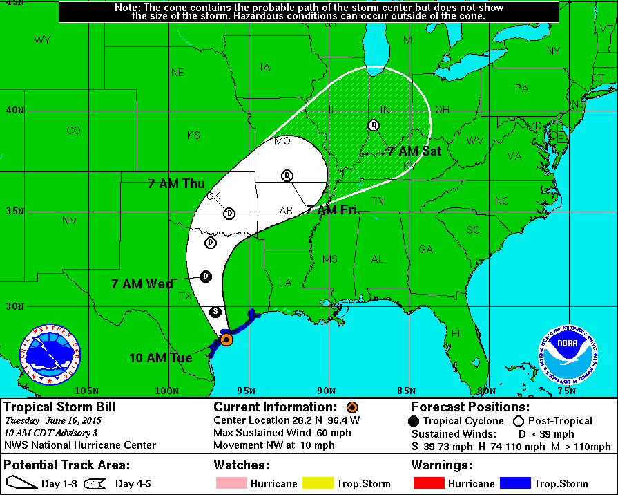
National Hurricane Center latest track on Tropical Storm Bill
VERY DANGEROUS SEVERE WEATHER SETUP TODAY AND TONIGHT
The Storm Prediction Center has upgraded our forecast area to a level 4 Moderate Risk for severe weather. All modes of severe weather will be possible, including a significant tornado threat. A Tornado Watch has already been posted for much of the forecast area. An eroding cap will give way to significant lift from an approaching dryline and large storm system lifting northeast onto the Central Plains from the Desert Southwest. Storms are already forming off the dryline and moving eastward just east of Abilene. A very moist atmosphere is in place across the area. There is 3000 to 4000 J/Kg for convective available potential energy (quite high) and moderate wind shear on the order of 300 M2/S2. Of real concern is backing surface winds across the area. All these parameters point to supercellular storm mode with any storm capable of producing large and strong tornadoes and giant sized hail up to softball/grapefruit size. In addition, heavy rainfall will be possible and some of the tornadoes could become rain wrapped and difficult to see. Residents of DFW should pay close attention to the changing weather conditions, and please take seriously any Tornado Warning issued for your area by taking appropriate action. Remember the best place to go is to an interior room, without windows, on the lowest level of the building or home.