
The Storm Prediction Center has upgraded our forecast area to a level 4 Moderate Risk for severe weather. All modes of severe weather will be possible, including a significant tornado threat. A Tornado Watch has already been posted for much of the forecast area. An eroding cap will give way to significant lift from an approaching dryline and large storm system lifting northeast onto the Central Plains from the Desert Southwest. Storms are already forming off the dryline and moving eastward just east of Abilene. A very moist atmosphere is in place across the area. There is 3000 to 4000 J/Kg for convective available potential energy (quite high) and moderate wind shear on the order of 300 M2/S2. Of real concern is backing surface winds across the area. All these parameters point to supercellular storm mode with any storm capable of producing large and strong tornadoes and giant sized hail up to softball/grapefruit size. In addition, heavy rainfall will be possible and some of the tornadoes could become rain wrapped and difficult to see. Residents of DFW should pay close attention to the changing weather conditions, and please take seriously any Tornado Warning issued for your area by taking appropriate action. Remember the best place to go is to an interior room, without windows, on the lowest level of the building or home.
RECORD LOWEST MAXIMUM TEMPERATURE SET AT DFW AIRPORT TODAY
DFW Airport has officially recorded a high of 59°F for today, April 28, 2015. This breaks the old record lowest maximum temperature of 61°F set in 1932 for this date.
NEW SITE FEATURES: NWS SHORT TERM FORECAST AND HAZARDOUS OUTLOOK ADDED
New website features have been added: The National Weather Service Short Term Forecast and Hazardous Weather Outlook. These items are not issued everyday, but are issued when active weather is in the area or expected to be in the area within the forecast cycle. You can access these new features by clicking on the “Forecast” link on the left navigation menu, then click on the item you wish to view from the pop-out submenu (i.e. “Short Term” or “Hazard Weather”). There is also a direct link to these features under the 2-Day Outlook grid on the home page.
FIRST SEVERE WEATHER SETUP OF THE SEASON TODAY AND TOMORROW
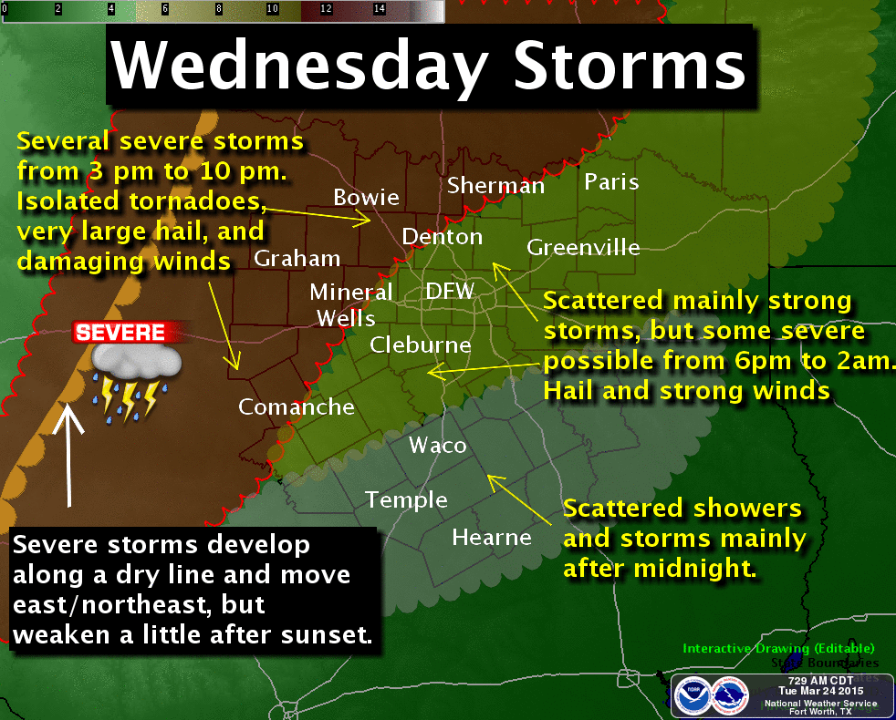
Severe weather setup for Wednesday afternoon into Wednesday night. Graphic courtesy of the National Weather Service office in Fort Worth, Texas.
UPDATE: The latest data is now suggesting that the CAP will hold strong over the forecast area greatly reducing any threat of severe storms over the immediate Metroplex. This is in part because a lead short wave is now expected to move across the area earlier today, around midday, with subsidence in its wake during peak heating hours. Thus, for the CAP to break, we must await the primary shortwave expected later this evening well after peak heating when instability will be much less. Still there is a chance of thunderstorms this evening, mainly elevated, with the primary shortwave and again with the passage of moderately strong cold front. Much cooler tomorrow with overnight lows Thursday night into Friday morning falling into the upper 30s to mid 40s across the area.
The first significant severe weather event of the season is taking shape across North Texas today, but especially tomorrow.
For today, a shortwave will track across the Central Plains sending a weak cold front into North Texas this afternoon. The main dynamics with this system appear to be too far removed from North Texas to be strong enough to break a strong capping inversion aloft. However, with the weak frontal boundary in place across North Texas, mesoscale forcing and frontogenesis combined with strong compressional warming may be just enough to weaken or break the cap along and east of a line from Weatherford to Gainseville and north of the I-20 corridor. As a result, have placed 20% POPs for isolated convection that could initiate in this region. As you approach the Red River into Oklahoma, convective inhibition becomes almost negligible and a much higher chance for convection exists. Temperatures are expected to rise well into the 80s, even the upper 80s to around 90 in some places due to the compressional warming from the front. This heating could be strong enough to lift the cap. Combine this with steep lapse rates, very cold air aloft, and CAPE approaching 2000 J/Kg, any storm that is able to get going will become severe and supercellular in structure with the potential of producing very large hail and damaging winds. With the wind fields rather weak in the lower levels, I expect the tornado threat today to be rather low, but non-zero. I am not expecting a widespread severe weather outbreak today in our area, but there is an isolated risk should convection be able to initiate. In all likelihood, the CAP will hold.
For tomorrow (please see graphic above), a much different scenario will play out. Another shortwave will eject onto the Plains, much further south than today’s. As a result, a surface low will develop near Wichita Falls with a dryline extending perpendicular south/southwest to the low and a cold front off to the north/northeast forming a triple point. This will increase surface winds across North Texas tomorrow. Most of the forecast area will be strongly capped, but as the dryline approaches a line from Comanche to Mineral Wells to Gainseville, the cap will begin to lift and convection should fire along the dryline. Across this area, CAPE will again reach 2000 J/Kg with strongly sheared low level winds. Thus, convection will rapidly become severe with the threat of very large hail, damaging winds, and tornadoes. The storms will be supercellular in structure and discrete initially, but will begin to organize into a squall line as the dryline marches eastward. Across the immediate DFW Metroplex, I expect the capping inversion to hold and cause approaching surface-based convection to be become elevated over the cap as the storms approach the I-35 corridor. This will greatly reduce the tornado threat here, but large hail and damaging winds will still be a threat as 1000 to 1500 J/Kg of CAPE will still be available across our area. Should the cap lift across the Metroplex, then the severe weather threat will increase with tornadoes possible.
2014-2015 WINTER IN REVIEW
Officially at DFW Airport, we had 40 freezes this winter, where the average is exactly 35 freezes per season (as calculated over the entire temperature record dating back to 1898). It is still possible to have another freeze before mid April, but not looking likely at this point. 5.80 inches of snow fell, pretty much all within the last week of February and the first week of March in a series of four winter weather events that is extremely rare in such a short span of time. We average about 3 inches of snowfall per winter season. The average overall winter temperature was approximately -0.86 below normal as measured between December 1st through February 28th.
SPRING FORWARD THIS WEEKEND
It is that time of year again. Central Standard Time (CST) ends Sunday, March 8, 2015, and we spring forward one hour to Central Daylight-Savings Time (CDT). Remember to set your clocks ahead one hour.
PRELIMINARY SNOWFALL TOTALS
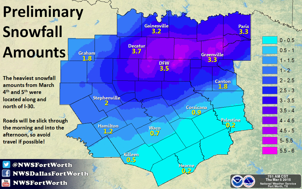
Preliminary snowfall totals for the March 4-5, 2015 storm. Map courtesy of the National Weather Service office in Fort Worth, Texas.
The graphic above shows the preliminary snowfall totals for the March 4th and 5th storm of 2015. The heaviest amounts were along and north of I-30. Most of this snow fell on top of a thin layer of ice and about a 1/4 to 1/2 inch of sleet. This event is the 4th heaviest snowfall on record for the month of March at DFW officially with 3.5 inches. Other notable March winter storms are as follows:
1. March 13, 1924 – 6 inches
2. March 1, 1942 – 4.5 inches
3. March 7, 1947 – 3.9 inches
4. March 4-5, 2015 – 3.5 inches
5. March 17-18, 1934 – 2.5 inches
THREE MORE CHANCES OF SNOW AND ICE THROUGH SATURDAY
An Arctic cold front traversed the region this morning advecting much colder air back into the region. Temperatures at this hour were right around freezing, or just below, across the forecast area. A shortwave trough was evident moving across the area on water vapor. This trough is responsible for moderate to strong lift across the region. However, around the Metroplex, there is considerable dry air at the surface to overcome and moisture is rather limited. Farther to the west and southwest of Fort Worth, a snow band has developed in a stronger area of frontogenesis bound by Haskell to Mineral Wells down to Hillsboro resulting in slightly heavier snowfall. Accumulations in this region could reach an inch or so. As a result, the National Weather Service office in Fort Worth has issued a Winter Weather Advisory for Parker and Hood counties in our forecast area. Across the Meteroplex, snow should stay rather light with weaker lift and drier air to overcome, though a dusting to 1/2 inch can’t be ruled out. The snow should taper off as lift decreases this afternoon as the shortwave moves off to the east.
Another stronger and larger shortwave trough will approach the area tomorrow. This trough will be slower to move across the area with longer duration of lift expected. However, moisture will still be limited. Depending on the exact tract of this trough (currently northwest of DFW), the highest snowfall accumulations will occur beneath it. This could change with later model runs, and given setup, the possibility exists for up to 2 inches of snowfall on Friday. With temperatures expected to largely be in the 20s, this could pose some travel impacts. This will be further assessed later in the day with the latest model data once the first system gets out of the picture.
The overall synoptic pattern will undergo a change Friday night through the weekend, that transitions us from a large scale trough in the center of the CONUS to one that favors strong southwest flow aloft. This will intensify overrunning of a warm air and moisture advection pattern aloft. With the Arctic airmass in place and temperatures below freezing Friday night into Saturday, periods of snow changing to sleet changing to freezing rain and drizzle will be possible. This will likely coat roadways with a few one hundredths of an inch of ice to possibly a tenth of an inch of ice with isolated higher amounts over much of the forecast area. This will be enough to cause some moderate impacts to travel Saturday. Temperatures will warm significantly on Sunday as a warm front is pushed across the area in the strong warm air advection pattern. This will effectively end all threat for frozen precipitation with switch back to all liquid rain. Some thunderstorms will be possible by Tuesday as instability increases ahead of another cold front.
WHY MANY MISSED OUT ON THE SNOW FOR THE MOST PART
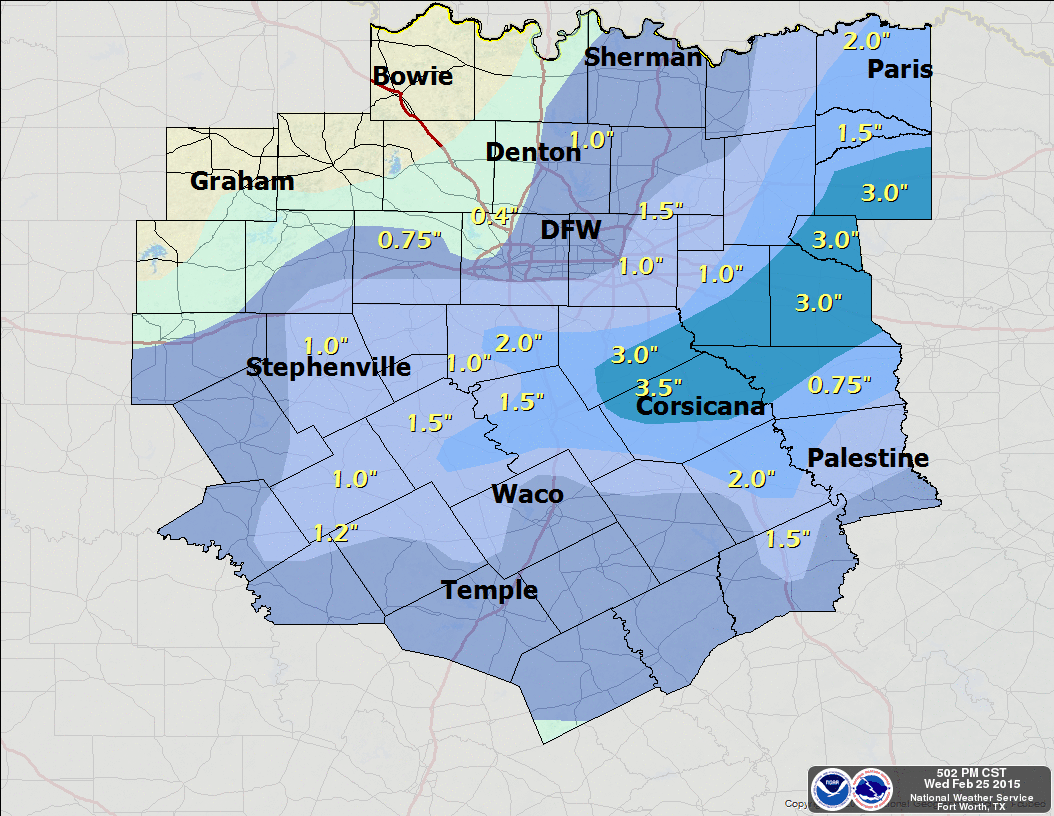
Snowfall totals for the Wednesday, February 25, 2015 snow event. Map courtesy of the National Weather Service office in Fort Worth, Tx.
The upper-low tracking across Texas moved a little farther south than expected. This further south movement allowed temperatures, at about 5000 feet above the surface, to be about 2°F warmer, across the immediate Metroplex and points north, than what they would have been if the core of the low tracked further north. This was enough to effectively have most of the snow that was falling in the upper atmosphere to melt and fall as rain and sleet at the surface. Where the upper low tracked further south, heavier snow did accumulate in a narrow band bound by Hillsboro to Terrell. The heaviest snow was in Navarro County where 3 to 4 inches fell. See graphic above for more detailed snow totals.
The snow/rain/sleet are moving off to the east, and we should see rapid clearing with sun all the way to the I-35 corridor by this afternoon. This will allow temperatures to climb into the 40s this afternoon. Another Arctic cold front is poised to move through the region tomorrow with more snow in the forecast for Friday. Friday’s snow will fall with temperatures in the 20s, but it will be light with not much in the way of moisture or lift because of a weaker wave embedded in the northern jet. Though, there could be some light accumulations.
WINTER WEATHER ADVISORY – POSSIBLY 1 TO 2 INCHES OF WET SNOW WEDNESDAY MORNING
The National Weather Service has downgraded the Winter Storm Watch to a Winter Weather Advisory for 1 to 2 inches of very wet snow with locally higher amounts up to 4 inches under the heaviest bands. The Advisory will cover all counties within the forecast area. The latest data suggests the heavier snows will now be off to our northeast. Thus, the requirement of widespread 4 inches or more of snow for a Winter Storm Warning will not be met. This appears to be a minor headache event and will not cause high impacts to travel. Temperatures, with adequate late winter sunshine, should warm rapidly above freezing tomorrow afternoon melting any snowfall.
The National Weather Service has expanded the Winter Storm Watch to cover all counties within our forecast area. Thus, Ellis, Johnson, and Rockwall were added to the Watch. The Winter Storm Watch is for the potential for heavy wet snow tonight. 2 to 4 inches with locally higher amounts can be expected.
The upper-low that ejected two disturbances across Texas that brought rain, freezing rain, and sleet to the area yesterday and today will eject directly across North Texas. This is a cold-core upper low that will cool thermal profiles all the way to the surface sufficiently to support snow. Depending on the exact tract of this low, heavy bands of convective snow will develop across North Texas. As a result, the National Weather Service has issued a Winter Storm Watch for heavy snow for Tarrant, Dallas, Denton, Collin, Wise, Ellis, Johnson, Kaufman, and Rockwall in our forecast area. The Watch is for Tuesday night into Wednesday morning as the best chance to see accumulating snowfall.
In the short-term, temperatures remain in the mid 20s across the area. Any residual water or slush on roads will refreeze tonight as temperatures drop into the lower 20s. In addition, patchy freezing drizzle may develop across the area glazing roadways with a thin glaze of ice. Residents are urged to proceed with extreme caution when heading out tonight or in the morning.