
The high yesterday, March 4, 2019, at DFW Airport was 32°F. This sets a new record low maximum temperature for that date, breaking the old record of 35°F set in 1960.
Tag Archives: News
OUR NEXT RAINMAKER FOR THIS WEEKEND [UPDATED]
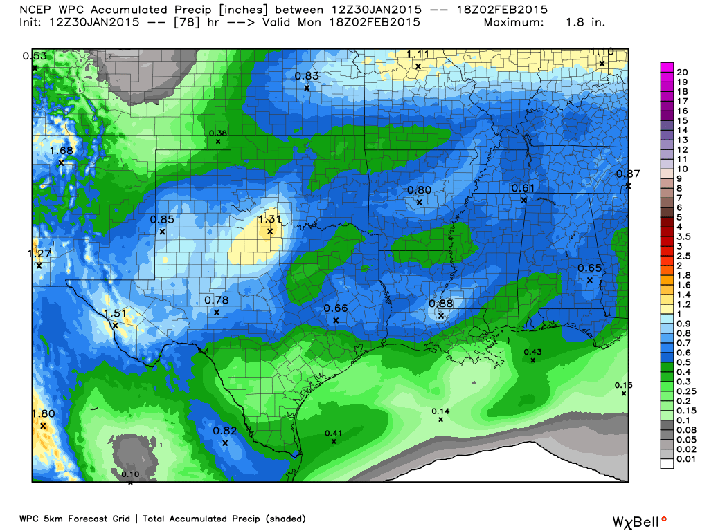
Average rainfall amounts expected for the weekend of January 31st through February 1st 2015. Map courtesy of WeatherBell.
Next weather system to bring much needed rainfall to North Texas Saturday into Sunday.
UPDATE: It looks as though our system that will bring us rain over the weekend is slowing down. Thus, the forecasts have been adjusted back about 12 hours for the onset of precipitation from prior forecasts. In addition, average total rainfall amounts with this system have been lowered to between 1/3 to 1/2 of an inch of rain across the area based on the latest model data. Please see above graphic for latest rainfall amounts expected across Texas.
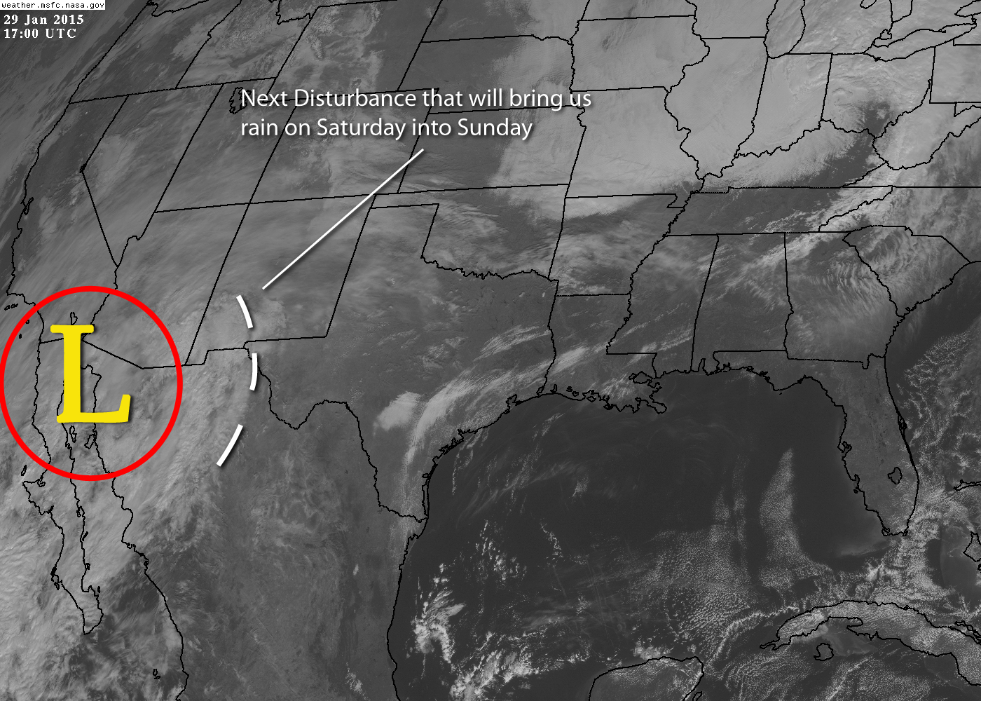
Our next weather system will be associated with an upper-level low sitting just off the coast of Baja California. The upper-low itself will move eastward a bit before moving south into Northern Mexico. As it does so, it will eject a rather strong upper-level disturbance northeastward into North Texas. This will set the stage for rain to develop from southwest to northeast beginning as early as Friday night. The rain should last into Sunday. As the disturbance moves off to the northeast, another cold front will plow into the region behind it. This will allow for a return to slightly below normal temperatures for early next week with a widespread freeze expected Monday morning. Don’t worry, the rain will be over by then with no threat of wintry precipitation. Total rainfall amounts with this event should average 1/2 to 1 inch across the region, which will be very much welcomed for our lakes. The upper-low will eject out across South Texas early next week bringing more rain to areas well south of the Metroplex.
WELL ABOVE NORMAL TEMPERATURES AND LOTS OF SUNSHINE OVER THE NEXT 7 TO 10 DAYS
The upper air pattern at 500mb will transition to one that supports a trough along the eastern 1/3rd of the nation and an expanding western ridge across the western 1/2 of the nation and semi rex block this into place. This will allow the coldest air to stay well east of Texas where a shot of Arctic air will blast the east coast. Meanwhile, Texas will be on the eastern fringe of the expanding western ridge. This will suppress any storm systems from affecting our region and allow temperatures to warm well above normal for this time of year. So, the forecast for the next seven days will see warming temperatures with abundant insolation.
We are watching very closely the next system that may affect Texas the weekend of January 31st/February 1st. While this is more than 10 days out, several global long-range models have been hinting that this system may try to phase with Arctic air, that may or may not affect the Plains during this time, and produce wintry precipitation across much of Texas. A lot can change over the next several days, but something to watch in the extended. It has been the pattern of this winter for the cold air and southern stream systems not to phase which leaves us with a lot of cold rain events. This may very well be the case with this system. However, given the tendency for this time of year to produce winter weather, nothing is out of the realm of possibilities at this time.
MORE ARCTIC AIR ON THE WAY WITH TEMPERATURES REMAINING BELOW NORMAL
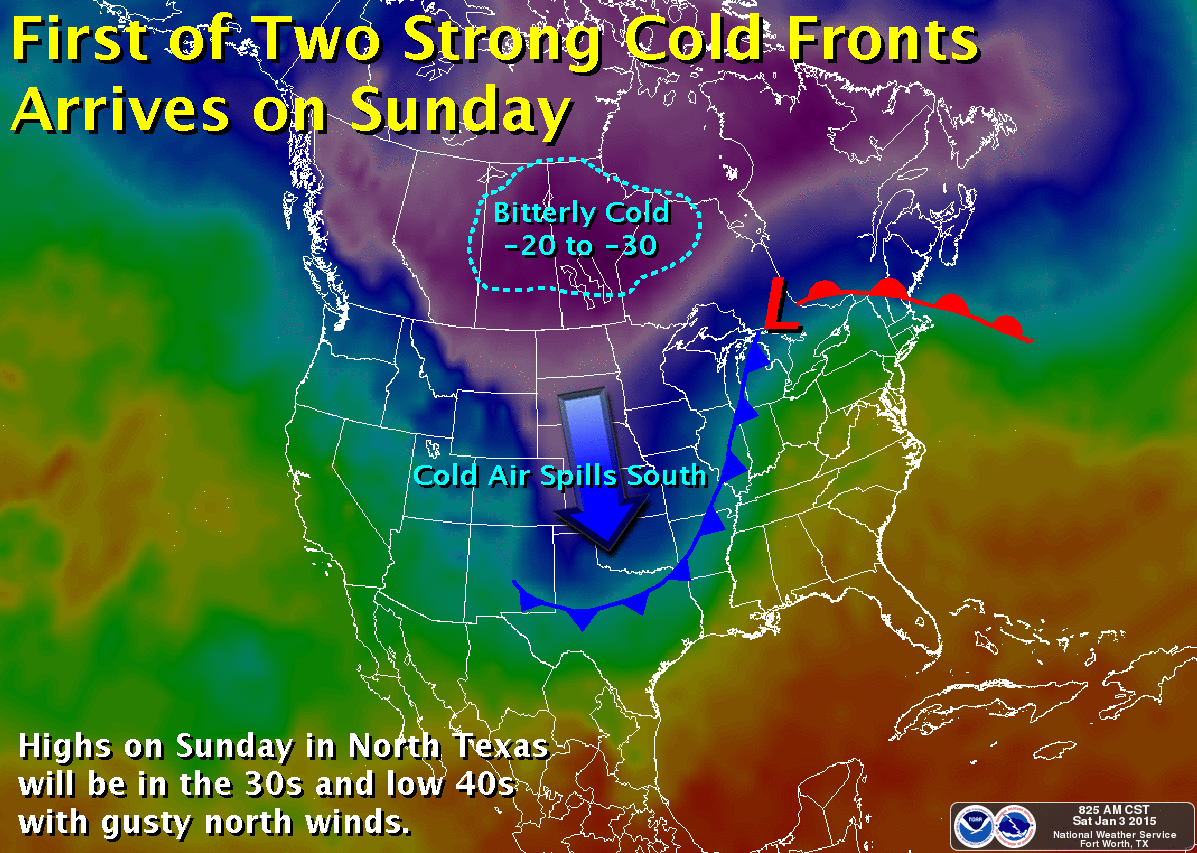
First of two Arctic cold fronts expected this week. Map courtesy of the National Weather Service office in Fort Worth, Tx.
The storm system that has brought all the ice to West Texas and all the rain to North Texas the last few days is now moving well off to the northeast. Rainfall amounts ranged a good 1 to 2 inches across the region. Enjoy the sun today and the southwest winds that will help temperatures warm into the 50s. It won’t last long! The first of two Arctic cold fronts will arrive tonight. Gusty northerly winds will usher in more Arctic air for tomorrow. Lows will plummet into the upper 20s by tomorrow morning with wind chill values down in the teens. It will be even colder Monday morning as high pressure, light winds, and radiational cooling help temps plummet into the upper teens to around 20°F.
Another, perhaps even colder, shot of Arctic air arrives on Tuesday. Some forecast models are depicting a 1060 mb surface high plummeting into the Plains with surface pressure approaching 1050 mb or 31.00 inHg in North Texas. It has been a long time since we have seen surface pressures anywhere near this magnitude in North Texas, and if true, would bring bitterly cold temperatures to boot. This is still a few days out and models can sometimes tend to over forecast surface pressures, but regardless it will be cold with lows likely by Thursday morning in the teens and lower 20s yet again. This is something we will continue to watch, if pressures do get as high as forecasted, surface temperatures would be even colder.
Unlike last week, this week will remain mostly dry with no threat of wintry precipitation, at least not right now. Unfortunately, the upper air pattern may remain highly amplified which could bring even more Arctic air to the region later in the month.
REMEMBERING THE “COBBLESTONE” ICE STORM THAT HIT DFW ONE YEAR AGO
The following article was written and published by the National Weather Service office in Fort Worth, Texas.
A major winter storm gripped most of North and Central Texas from December 5th through the 10th, 2013, severely impacting travel and power throughout the region. Freezing rain, sleet, and a little snow began falling during the afternoon of the 5th, and persisted through the morning hours of the 6th. As dawn broke on December 6th, a thick layer of ice encased much of North and Central Texas. Just about everyone north of a Goldthwaite to Hillsboro to Palestine line had ice on the ground at this point, including the entire DFW Metroplex. Sleet and ice measured as deep as 5″ in some areas, particularly in a swath extending from Denton, through Sherman, to Bonham.

Ice accretion amounts across DFW from the “Cobblestone” ice storm that hit the area exactly one year ago. Map courtesy of the National Weather Service Office in Fort Worth, Texas.
As challenging as these fresh accumulations were for residents and travelers, the prolonged cold would make things worse. Temperatures dropped below freezing late in the day on the 5th, and would remain in the ice box for most of the next 5 days. The recurring combination of tire compaction, melting/re-freezing, and sand treatment would transform the initial frozen precipitation into rock hard formations, which would eventually be referred to as “cobblestone ice”. Most area streets and highways in the Metroplex and points north were subjected to these challenging conditions, forcing residents to remain at home for several days. Further south, conditions were a bit better, though ice did linger on bridges, overpasses, and elevated surfaces. Hundreds of cars and trucks were stranded for long periods on many of the main highways, particularly Interstate 35 from Fort Worth to the Oklahoma border, and Interstate 20 from Fort Worth going west.
While travel disruption was a major impact from this winter storm, power and property were others. Thousands of tree branches and power lines were downed by the weight of ice, particularly from Fort Worth, north and east to Paris. At the peak of the storm, 275,000 customers were without power in the North Texas region. Ice-laden tree branches crashed into vehicles, homes and other structures, sending thousands of residents scrambling for their insurance adjusters. Early estimates from the Insurance Council of Texas topped $30 million in residential insured losses. This figure did not include damage to vehicles or roads. Many roads and bridges were directly damaged from the ice – or from attempts to remove the ice using plows and graders. The clean-up from this event took weeks and even a few months in some places.
Most schools, especially in the hardest hit areas, were closed for several days, and thousands of businesses were forced to close for at least a day or two. Airlines at DFW Airport and Dallas Love Field cancelled hundreds of flights, and thousands of flyers were sheltered at both airports during the storm. Seven fatalities occurred during this event; 4 in vehicles, 2 from exposure, and 1 from a fall on the ice. Hundreds of injuries were also reported due to falls on the ice.
A Little More About Cobblestone Ice. Why Did It Form?
One of the most memorable aspects of this particular storm was the introduction of “cobblestone ice” into the common vocabulary of North Texans. So why did it form, and why did it get so bad?
First off, it goes without saying that there was an abundance of precipitation with this event. Many areas received over an inch of liquid, including DFW Airport, where 1.25” of liquid was observed. North and east of the Metroplex, totals were even higher. This translated into multiple inches of snow, sleet and/or freezing rain which existed in layers of varying depth. As traffic and marginal air and ground temperatures began to work on this frozen mess, some of it melted partially and morphed into slush during the daytime hours. Once nighttime fell, however, most of it would refreeze and harden. Despite the best efforts of local and state road crews, this cycle of compaction, melting, refreezing and hardening repeated itself in some areas over a period of up to 4 days.
In some spots, particularly on bridges and overpasses, larger chunks of ice were broken out of the icepack by plows and traffic. These chunks would mix in with the slush during the daytime, forming a soupy gray mess. At night, the entire concoction would refreeze, producing large molded bumps that were essentially glued to the very top of the roadways (or bridge decks). It was these hard, rock-like formations that represented the essence of the cobblestone ice experience for North Texas drivers.
Once frozen in place, this unique ice proved quite difficult to remove. Depths ranged from ½” to 4”, depending on where traffic caused peaks and valleys in the slush before it froze into cobblestone form.
While not a frequent occurrence, winter precipitation is no stranger to North and Central Texas. Fortunately, the cobblestone ice phenomenon is quite unusual. In addition to the magnitude of ice, it was the sustained period of cold temperatures following the event – interspersed with episodes of melting – that promoted the rough driving conditions. The only sure way to prevent this from happening in the future will be to remove most of the sleet and snow from the roadways before it gets a chance to melt and refreeze. Unfortunately, it may be difficult for local and state public works and transportation departments to achieve this lofty goal, given the thousands of miles of roadways under their jurisdictions. Having said this, local cities and counties, the State of Texas, and the National Weather Service in Dallas/Fort Worth did learn a great deal from the December 6th, 2013 storm – and these lessons will surely benefit all of North and Central Texas during future events.
RAIN CHANCES RETURN TO DFW WITH WARMING TEMPS

Current weather map for December 2, 2014, courtesy of WeatherBell.
The Arctic airmass that has settled across DFW and the rest of North Texas on Monday will begin to erode, as the Arctic high slides east and a rather intense warm air advection pattern begins. Our winds will become south/southwesterly today and back more south/southeasterly tonight. This will allow warmer air to begin overriding the colder air at the surface. Well after midnight tonight, areas of fog and drizzle will begin to develop across the forecast area. Some of the fog could be rather dense at times with visibilities below 1 mile. The fog and drizzle will be very slow to burn off on Wednesday and will hang in for much of the morning. Given the pattern, we will keep low chances of light rain showers in the forecast through Friday. Temperatures will begin to warm to near normal, or slightly above, (60s/70s) as we head into the middle and latter part of the week.
By Friday, rain chances will increase as a shortwave approaches (courtesy of weakening upper low moving ashore off the California and Oregon coast) in conjunction with a cold front from the north. Widespread rain will be possible with isolated thunder as dynamics increase ahead of this system. The cold front is expected to move across Friday evening with a combination of Pacific and Canadian air. This front will not be nearly as strong as the Arctic front that moved through early Monday morning. However, it will keep temperatures below normal heading into early next week as another stronger disturbance and cold front arrives. This will bring additional rain chances to the region as we head into next week.
DFW AREA LAKE LEVEL RISE SINCE WEEKEND RAIN EVENT
The system over the weekend brought much needed rainfall to the area. Many of the area lakes benefited from the rain. Below is a map showing the area lakes and how much of a rise they gained after the event. Belton, Cisco, and Limestone all showed the greatest gains with 5 inch increases. Lake Ray Hubbard set a new all-time record low level just before the rain event.
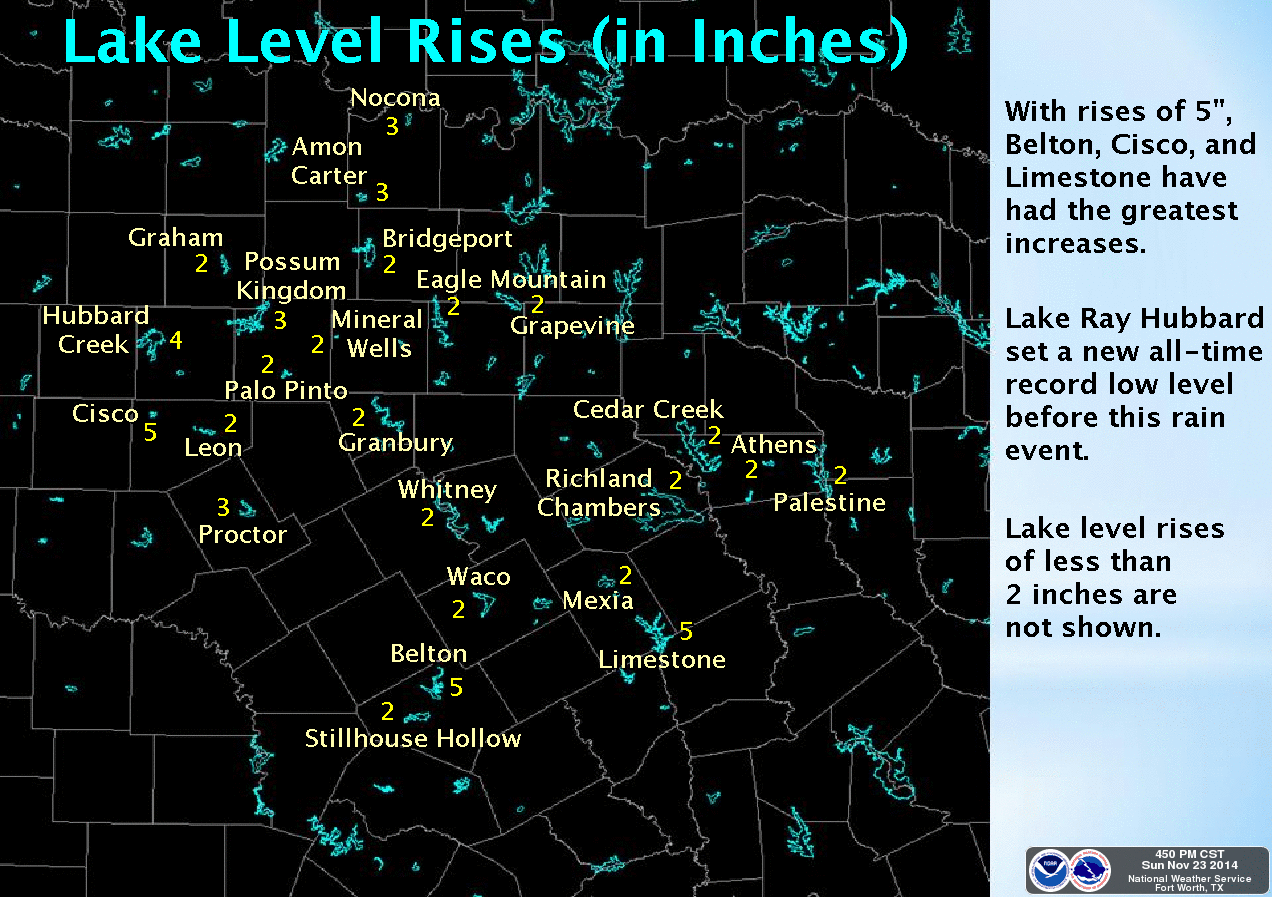
DFW area lake level increase since the weekend rain event. Data courtesy of the National Weather Service in Fort Worth.
LATEST FORECASTED RAIN TOTALS FOR DFW THROUGH SUNDAY
Our big storm system is on its way. The system is now onshore over California and will be moving over North Texas tomorrow. This continues to look like a widespread, mult-inch rain event for the DFW area. 2 plus inches of rain is possible, especially from the DFW Metroplex north and west toward the Red River counties with isolated amounts up to 4 inches in some of the heavier downpours. The data continues to suggest the severe weather threat will remain well south and east of the Metroplex; although, it is still possible that one or two strong storms cannot be entirely ruled out in our area.
Weather Prediction Center of expected rainfall totals across the Sate. Data courtesy of WeatherBell.
The biggest concern will be the potential for heavy rainfall in our area as pWATS (precipitable water) levels increase to 1.50 inches. Well above normal for this time of year. We are still in extreme drought conditions, thus runoff will be absorbed well by area lakes and area soils very dry. Therefore, widespread flooding is not a concern, though localized, urban flash-flooding will be possible.
UPDATE ON MAJOR RAIN EVENT FOR FRIDAY AND SATURDAY
A big storm system, currently located a few hundred miles off the coast of Oregon and northern California (see pic), will be our next weather maker here in DFW. This storm system promises to bring much needed rainfall to the region. Latest data continues to suggest this to be a multi-inch rain event beginning late tonight in our northwest counties through Sunday.
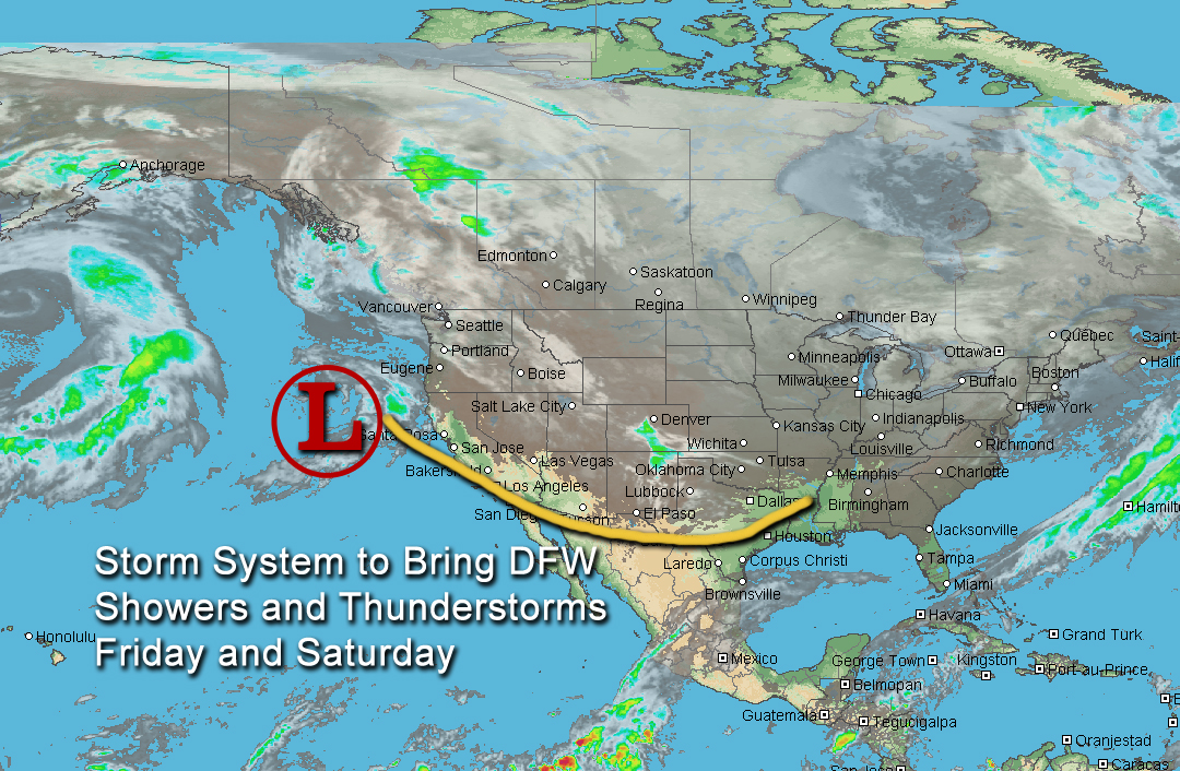
Satellite image of the storm system that will bring beneficial rainfall to DFW.
Areas from the DFW Metroplex northward to the Red River counties stand the best chance to see 2 to 4 inches (with isolated higher amounts) of rain with this system by Sunday, as locally heavy rainfall will be possible in some of the storms. Flash flooding may not be widespread due to drier soils, but local flash flooding will be possible in the heavier downpours. As the system crosses the forecast area, the associated trough will become negatively tilted (one of the strongest weather system types) which will inhibit a capping inversion aloft. This will allow for surface-based convection with increasing instability leading to the potential for severe thunderstorms out ahead of the trough. Large hail, damaging winds, and tornadoes will all be possible with this severe weather threat. While one or two strong to severe thunderstorms cannot be entirely ruled out in the DFW area, the latest data continues to suggest that the best severe weather threat still looks to be south and east of the DFW Metroplex.
WARMING TEMPS AND MAJOR RAIN EVENT FOR FRIDAY/SATURDAY
We are finally beginning to warm up as the Arctic high releases its grip over North Texas. The Arctic high and trough are moving east allowing our winds to turn around to the south. This will advect warmer air and moisture into the area. You will be noticing warmer temperatures beginning today, with forecasted highs in the 60s and even warmer tomorrow as we climb into the mid-to-upper 60s. By Friday, a strong system will approach DFW in the southern jet enhancing moisture advection out ahead of the system.
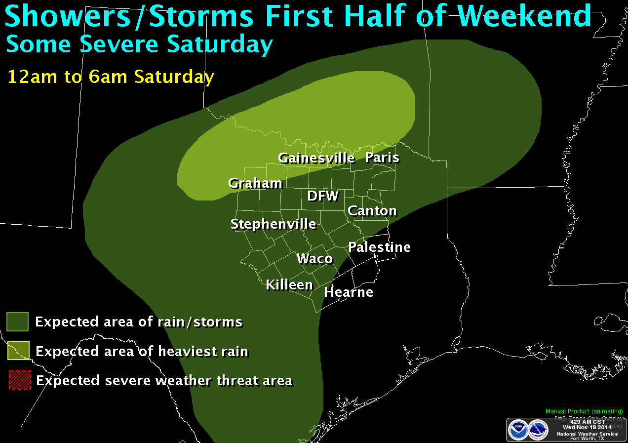
Animation of rain event expected over the forecast area Friday through Saturday. Courtesy of the National Weather Service office in Fort Worth, Texas. Click on the image for the full animation.
This will set the stage for numerous showers and thunderstorms, beginning as early as Thursday night in our northwest counties and area wide on Friday. Some of the showers and storms could produce heavy rainfall, especially on Saturday. Strong to severe weather will also be possible by Saturday, but mainly south and east of the forecast area. This is looking like it could be a multi-inch rain event for the area; however, it is much too soon to pinpoint rainfall amounts. As we get within 24 hours of the event, better data arrives and we will be able to determine more precise rainfall amounts. This is good news as the area does desperately need rainfall.
Don’t get too comfortable with the warmer temps as a cold front arrives on Sunday knocking our temperatures back down. This cold front will not be near as cold as the ones last week. However, things are beginning to come together for another Arctic blast over Thanksgiving weekend. More on that later . . .