Category Archives: Forecast Blog

TOTAL SOLAR ECLIPSE FOR DFW ON APRIL 8, 2024

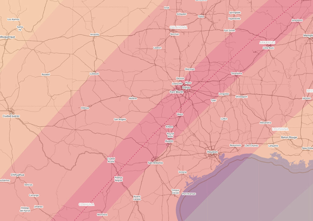
A truly rare event is coming to the DFW Metroplex, a total solar eclipse on April 8, 2024. The map below shows the path of totality of the eclipse in dark pink with the red dashed line representing the center of the total solar eclipse path. The lighter shades represent variations of partial eclipse viewing. As you can see, the DFW Metroplex is in the northwest quadrant of the path of totality. The last time Dallas and Fort Worth experienced a total solar eclipse was on July 29, 1878. We will not experience another one until June 30, 2345. So, it is truly a once in lifetime experience. A total solar eclipse is different than a partial solar eclipse and much rarer. For more information on the upcoming eclipse, please visit: weather.gov/fwd/eclipse2024.

MAJOR ARCTIC AIR WITH THREAT FOR SEVERE COLD FOR THE MLK WEEKEND

DFW’s mild winter is about to come to an end. A very impressive Arctic airmass will be building and plunged south into the heartland of the CONUS over the weekend, indicative of a ~1045mb high pressure system. This all teleconnected very well with negative EPO, negative WPO, negative AO, and negative NAO. This will produce the coldest weather for this winter by a long shot for DFW. There is an increasing concern that temps could fall below 10°F at the coldest point which is the threshold for severe cold for this region and necessitate Hard Freeze Warnings for the area. This type of cold can damage agriculture and infrastructure this far south as we saw in February 2021. At the very least, we are confident temps will fall to the teens Monday and Tuesday next week for DFW with high temps struggling to get out of the 20s. At this time, it is not anticipated that the cold will be anywhere near the magnitude of February 2021, or last as long. There is a small chance that we may see some impactful wintry precipitation Sunday night into Monday. Not all of the models are on board with this scenario, but enough are that we will be monitoring that closely. Of course, any frozen precipitation will only exacerbate the cold. If you have not winterized your homes, now will be a good time to do so.

HOURS BELOW FREEZING LAST WEEK

During last week’s wintry weather, some locations remained at or below freezing for more than 100 hours. Hearne rose above freezing during each day of the event, but Granbury remained at or below freezing from late Sunday (January 29) until early Friday (February 3), a total of 111 consecutive hours. Officially at DFW Airport, the total number of consecutive hours below freezing was 88 hours. The all time record number of consecutive hours spent below freezing for the DFW Metroplex is 295 hours from 7:00 am December 18, 1983 to 2:00 pm December 30, 1983.

SEVERE ICE STORM UNFOLDING FOR THE WESTERN PART OF THE METROPLEX

The National Weather Service office in Fort Worth is upgrading the Winter Storm Warning to an Ice Storm Warning for the western half of the Metroplex including Fort Worth for tomorrow into early Thursday. The potential exists for severe icing on top of the already 1/2 inch of sleet or so. There could be an additional 1/2 inch of ice accretion from moderate to heavy freezing rain tomorrow. This would make travel nearly impossible and hamper the improvement of roadways in this area until late Thursday or early Friday. This amount of ice could potentially cause widespread power outages, especially in areas that have above ground power lines. The weight of the ice can bring them down, and also bring down tree limbs that fall on the power lines. Travel in Tarrant, Parker, Hood, Denton, Johnson, and Wise counties is strongly discouraged.

ICE STORM TAKING SHAPE FOR DFW FOR MONDAY THROUGH WEDNESDAY

An Acrtic airmass is barreling south and should reach the DFW Metroplex by sunrise Sunday morning. Temperatures should plummet 10 to 20 degrees with a an hour or so behind the front. Sunday’s high temperatures are occuring now. This airmass is very dense but shallow, only about 1 km thick vertically. It will also hang around most of the upcoming week.

As cold air advection intensifies Sunday evening, temperatures will drop below freezing all the way to Waco Monday morning. An upper level storm system will approach from out west setting the stage for freezing drizzle on Monday. This will start the icing process on bridges and overpasses. Because it is drizzle, roads may look fine, but are actually coated with a glaze of black ice. Motorists should be very cautious traveling on Monday.

Conditions will worsen Monday night into Tuesday as temperatures get colder and precipitation ramps up. Sleet will also be mixing in with the freezing rain. Total ice accretion from this event depends on several factors and not entirely known at this time. However, it is becoming clear that ice may cause major travel headaches from the DFW Metroplex north and west. There may be enough ice accretion to warrant a Winter Storm Warning for part or all of the forecast area. Please stay alert to changing weather forecasts and conditions.

SEVERE COLD EXPECTED THIS CHRISTMAS AT DFW

Key Messages:

  • Severe cold Arctic outbreak expected for Christmas. Arctic front arrives early Thursday.
  • Very cold temperatures with lows in the single digits both Friday and Saturday mornings.
  • Wind chill values will be below zero Thursday night into Friday morning.
  • Very strong winds expected on Thursday behind the front.
  • No snow or ice is expected outside of a few flurries.
  • Temperatures to stay below freezing for 72 hours (from Thursday to Christmas Day)
  • Pipes will burst if not properly wrapped and protected
  • This will be the coldest Christmas since 1989.

A major Arctic airmass that has been building in Canada seeded by air from Siberia will plunge southward into the lower 48 this week. The high pressure associated with this airmass is progged to be some 1060+ mb and may challenge high pressure records for the lower 48. This will undoubtedly bring a severe cold snap to much of Texas for the holiday. Residents, especially those planning on being out of town, should prepare their homes by wrapping their pipes. Temperatures at the coldest point could potentially reach the upper single digits at DFW. This is cold enough to cause infrastructure damage in this region and is considered severe cold. Freezes will likely reach all the way into Northern Mexico and into the Lower Rio Grande Valley with this.

The Arctic front is expected to arrive on very early Thursday with plunging temperatures behind it. Temps will likely be in the single digits across all of North Texas by Friday morning with wind chills below zero. This will not be a repeat of the cold air outbreaks of December 1983, December 1989, or most recently, February 2021. We simply will not get that cold, nor is the longevity of this cold air outbreak expected to be that long. However, this will be the coldest Christmas since 1989 for DFW. Freezing temperatures are expected for about 72 hours from Thursday to Christmas Day. We are not expecting any ice or snow with this cold outbreak at this time. Residents are urged to take proper precations to winterize their homes, including wrapping exposed outdoor pipes. Pipes will freeze and burst in this type of cold.

5TH COLDEST FEBRUARY ON RECORD AT DFW MAKES ABOVE NORMAL WINTER BELOW NORMAL

The severe cold spell that we had a couple of weeks ago had temperature anomalies so great that it made February the fifth coldest on record at DFW. In addition, prior to that, the 2020-2021 winter season was averaging 1.7°F above normal, and the cold spell turned an above normal winter below normal. Now the winter average is 1.8°F below normal.

The mean average temperature for February 2021 at DFW was 41.1°F a whopping 8.9°F below normal. The top five coldest Februarys in DFW history are as follows:

  1. February 1905
  2. February 1978
  3. February 1899
  4. February 1929
  5. February 2021

WINTER STORM WARNING – HISTORIC WINTER STORM – DANGEROUSLY SEVERE COLD

Key Messages:

  • Winter Storm Warning in effect until Monday for the entire forecast area
  • Snow accumulations 3 to 7 inches with possible higher snow drifts
  • Temps plunging to near all-time record cold temps on Tuesday with lows near 0°F
  • Windchill values 10 to 20 below zero
  • Hypothermia and frostbite can set in quickly in this type of dangerous/severe cold
  • This will be the coldest in 30 plus years!
  • This will be a prolonged cold snap
  • Temps will not get above freezing until next Saturday
  • Blowing and drifting snow
  • Near Blizzard conditions at times Sunday night
  • Whiteout conditions possible Sunday night
  • Travel becoming treacherous to impossible for all of the coming week
  • Major damage to infrastructure and agriculture from the cold
  • Another major winter storm expected Tuesday night into Thursday
  • Governor Abbott has declared all of Texas as a disaster area

Folks—we cannot stress this enough—you are about to witness a historic winter weather event. It cannot possibly get any more severe than this. This will rival the great cold air outbreaks of December 1989, December 1983, January 1930, and yes the king of them all February 1899. This will be a protracted cold snap. DFW Airport has already spent the last 72 hours below freezing and counting. We are not expected to rise above freezing until next Saturday afternoon at the earliest. This will make for the longest stretch of subfreezing conditions at DFW since December 1983. Major agricultural and infrastructure damage will result from such cold. Governor Abbott has issued a disaster declaration for all of the state of Texas. You have narrow window today to do final preparations before things deteriorate rapidly.

Areas of freezing drizzle this morning are coating surfaces, including roadways with a thin glaze of ice. Motorists are urged to exercise extreme caution this morning if traveling. The freezing drizzle should end this afternoon, with a lull before the next precipitation starts this evening as the main shortwave trough approaches Texas. Areas of freezing drizzle and sleet will begin tonight and ramp up significantly after sunrise on Sunday. The ground surface is frozen after 72 hours and going on 96 hours of subfreezing temperatures at DFW Airport. This means precipitation will stick instantly as it falls to the ground causing roads to deteriorate rapidly on onset. Snow will become widespread and heavy Sunday night. Because of the powdery nature of the snow, much like you would find at a ski resort, it will easily be blown around. Winds are expected to be near 30 mph at times causing blowing and drifting of snow and near blizzard conditions at times. Visibilities will be reduced to near 0 at times causing whiteout conditions. It is strongly recommended that no one travel during this time. Snow ratios may be 15:1 to 20:1 as opposed to our typical 10:1 because of the extreme cold. Total accumulations expected are 3 to 7 inches. Snow drifts could easily exceed 7 inches. It must be stressed that not everyone will see 7 inches and some places could exceed 7 inches, and some places could be a little less than 3 inches. However, everyone should see at least 2 inches of snow.

On top of all of this a frigid Arctic airmass will continue to be advected south. We are dealing with, as stated above, the coldest weather DFW has seen in 30+ years. Temperatures will be close to 0°F by Tuesday morning. Breaking the daily low temperature record and getting near the all-time low temperature record for DFW of -8°F set on February 12, 1899, though that should be safe. We have already gone 72 hours at DFW Airport below freezing. We are not expected to rise above freezing until next Saturday afternoon at the earliest. This will be the second longest stretch of subfreezing conditions ever recorded. The record is December 1983 with 12 days of subfreezing conditions. This is life-threatening cold we are talking about. Frostbite and hypothermia can set in quickly in this type of cold. Hard Freeze Warnings and Wind Chill Warnings will likely be necessary.

Precautions should be completed today to protect people, pets, livestock, and exposed pipes. This type of prolonged cold will cause extensive damage to infrastructure and agriculture locally and across the state. Pipes can freeze and burst in such extreme cold.

WINTER WEATHER ADVISORY – COLDEST AIR IN DECADES FOR DFW

UPDATE: The Winter Weather Advisory has been expanded to include all of the forecast area. The expectation is the precipitation will be a bit heavier tonight in the form of actual freezing rain and sleet. Ice accretion in the advisory area is expected to be up to 1/4 of an inch with isolated amounts slightly higher. Since amounts reaching 1/4 of an inch will be more isolated, they have foregone a Winter Storm Warning at this time. Regardless, this will be enough ice to cause problems on not only bridges and overpasses but secondary roadways as well. Thursday morning commutes could be very problematic. Temperatures are expected to be in the 24-28°F degree range in the advisory area. DFW Airport forecasted low is 25°F.

Temperatures dropped to the middle to upper 20s, a couple of degrees colder than most models, this morning across the Winter Weather Advisory area which was expanded to include Dallas and Tarrant Counties. Widespread freezing drizzle has been occurring. Motorists should exercise caution when commuting this morning for possible icy bridges and overpasses and black ice patches. The advisory now runs through noon on Thursday as another disturbance pivots across the area bringing more in the way of light freezing rain and sleet tonight into tomorrow. Temperatures should have no trouble getting into the mid 20s again tomorrow morning. Areas that fall below 28°F may have more widespread issues with all roadways.

We will continue to see one Arctic surge after another through the coming 7 days. The coldest of which will occur on Saturday night through Wednesday. There is confidence that we, at some point at DFW Airport, will get to 12°F or colder, which will make for the coldest temps since 1996. If the mercury reaches 7°F, it will be the coldest since December 1989. Regardless of how cold it actually gets, it does look like temps will reach severe cold category with dangerously cold wind chills approaching 10 below zero at times. Hard Freeze Warnings and Wind Chill Warnings will likely be needed at some point.

There will be a quick shot of sleet and snow with the Arctic front on Saturday. However, it will get shut off rapidly by the deepening cold air. Models are now coming into better agreement on a more significant winter storm (likely all snow) Sunday night into Monday. If we get a snowpack, it will only exacerbate the bitterly cold temperatures. This is still several days out and the forecast will likely undergo many changes. More on this potential as more data becomes available.

SIGNIFICANT SEVERE WEATHER OUTBREAK EXPECTED TODAY LATE AFTERNOON WELL INTO THE EVENING

A potentially significant severe weather episode is unfolding for the forecast area later this afternoon well into this evening. The Storm Prediction Center has placed the entire forecast area in the Enhanced Risk category for severe weather. Please see the map below. The Enhanced Risk area is in orange, the Slight Risk area is in yellow, the Marginal Risk area is in dark green, the lighter green area means non-severe convection is possible.

Setup: A powerful upper level trough will be digging into the western portions of the state. A dryline will setup ahead of this system and begin surging eastward. Copious moisture advection from the Gulf will be pulled northward, indicative of dewpoints surging into the upper 60s/70s. CAPE (convective available potential energy) values in this moisture laden, warm atmosphere will climb to around 3000 to 3500 J/Kg with shear in excess of 50 knots.

What to Expect: Discrete cells should begin firing along and ahead of the dryline and possibly as far east as the I-35 corridor late this afternoon. These will rapidly become severe producing gigantic sized hail in the Enhanced Risk area. It will be possible for hail to reach baseball, or even softball, size in this type of environment. Over time these cells should grow into a QLCS (quasi-linear convective system) and push eastward with an attendant damaging straight-line wind threat. With the discrete supercells, especially ahead of the dryline, a few tornadoes cannot be ruled out. The tornado threat should wane as the storms form into QLCS. Another line of storms may approach the area later tonight along the actual cold front.

When: Wednesday, April 17, 2019 between 5:00pm and Midnight.

Please stay alert to changing weather conditions and heed any possible warnings that may be issued for your location.


Storm Prediction Center severe weather outlook for Wednesday, April 17, 2019. Damaging winds, giant hail, and a few tornadoes are possible in the Enhanced Risk area which covers the entire forecast area.