
DFW Airport finally drops below the 30°F mark this morning (January 10, 2016) with a low temperature of 28°F. This sets a new record of being the latest in weather recorded history to drop below 30°F during the cold season. The prior record was January 8, 1932.
SNOW NEXT WEEK? MAYBE NOT SO MUCH [UPDATED]
UPDATE: There continues to be no additional data that there will be snow or any wintry precipitation on Monday. There has been a lot of hype that there was going to be a snow or winter weather event on Monday for the DFW area. We are getting a shot at some modified polar air tomorrow, but the latest data suggests that this air mass will not be all that cold. In fact, DFW may struggle to get below the 30°F mark, yet again, on Sunday and Monday mornings. It is true that a very weak disturbance will traverse the area on Monday, but the lower 2000 feet of the atmosphere looks to be at or above freezing. This disturbance will have very little moisture to work with and have to overcome a very deep layer of dry air above. Thus, any precipitation would likely evaporate or sublimate before reaching the ground. This is a phenomenon we refer to as virga. The upper air pattern is not one that is favorable for significant moisture return or setup for a big winter weather event for DFW. We continue to see no indication of a major intrusion of Arctic air or wintry precipitation within the next 10 days. El Niño winters tend to prevent deep intrusions of Arctic air very far south, and in this particular winter, source regions are not all that cold. Thus, rather mild low temperatures (for this time of year) look to continue for several days. This means it will be hard enough to get us to freezing, much less cold enough for any significant wintry precipitation to cause problems.
For starters, a couple of short wave troughs will be moving across the area today and tonight which will be our next rain maker. The second trough is the stronger of the two, and that will be our best chance at seeing rain. This will not be a big thunderstorm or severe weather event. The atmosphere is too stable for big thunderstorms, though a clap of thunder or lightning strike cannot be entirely ruled out. There will be some drizzle and light rain today that will increase to a light to moderate rain later this afternoon into tonight as the stronger disturbance spreads lift across the area. Most locations will likely see some rain from this, but the heaviest rainfall will be east of the I-35 corridor. Rainfall amounts should generally stay around an inch or less with the heavier amounts further east.
Rain chances will end by tomorrow morning rapidly from west to east as the shortwave troughs move off to the east. Tomorrow will be sunny and much warmer with temperatures rising well above normal into the upper 60s. A repeat performance again on Friday, but a strong Canadian/modified Arctic airmass will be surging southward on Friday.
This front will move through the area early Saturday morning bringing much colder air to the region. It is likely that both Sunday and Monday morning lows will be below freezing area wide. Just how cold the temperatures drop will depend on cloud cover. Right now it looks as though our first dip below 30°F will be possible by Monday morning at DFW Airport. DFW has yet to do so this winter season, and a new record will be set to be the latest in the winter season to fall below 30°F. The previous record was January 8, 1932 (29°F).
At the same time, several models are bringing a weak disturbance across the area and producing snow on Monday. There have been widespread rumors across social media from various sources that this could be a big snow event. Well, there are several problems with this setup. One, it is not a favorable pattern for bringing moisture to our area, thus the weak disturbance will be moisture starved. Second, the disturbance is weak and not very strong. The upper air pattern is not one that has historically brought substantial snowfall to our area. Then, there is the question of how cold it actually will be when there is precipitation as nearly all models warm us above freezing on Monday. At this time, it is still possible that some flurries or light snow can fall on Monday with the passage of the disturbance, but there is nothing in the data to suggest more than that. This certainly does not look like a major winter storm at this time. While it is possible to snow, the chances are very low that precipitation can form in the dry air and that it will be cold enough to support wintry precipitation. For these reasons, we are not forecasting snow at this time. This may change with future data, but right now the forecast will remain dry and chilly for next Monday.
DFW 2015 YEAR IN REVIEW
2015 was the 19th hottest year on record for DFW with an average temperature of 67.2°F. December 2015 was the second hottest on record behind 1933 for the area with an average mean temperature of 53.6°F. It was the wettest year in all of DFW weather recorded history with an incredible 62.61 inches of rainfall. May 2015 was the wettest May ever recorded for the area with a whopping 16.96 inches of rainfall. Thanksgiving 2015 was the second wettest Thanksgiving of record with 2.71 inches of rainfall. The highest temperature for the year was 106°F on August 9th and 10th. The lowest temperature for the year was 16°F on January 8th.
SOME SNOW WILL BE POSSIBLE TONIGHT INTO TOMORROW ACROSS THE FORECAST AREA
As our much advertised vigorous upper-level storm system moves across the area this evening, rain will become mixed with sleet and snow from west to east in the areas depicted in the map below. The highest accumulations are expected mostly outside our extreme western counties where 1 to 3 inches are possible and a Winter Weather Advisory has already been hoisted by the National Weather Service office in Fort Worth. A dusting to under an inch will be possible in our northwestern counties. Closer in to the heart of our forecast area, wet snow flakes will be mixing in with the rain with a brief window for a transition to all snow early tomorrow morning before precipitation shuts off. However, temperatures will be at or above freezing and coupled with recent warm grounds, we expect little to no accumulations in these areas.
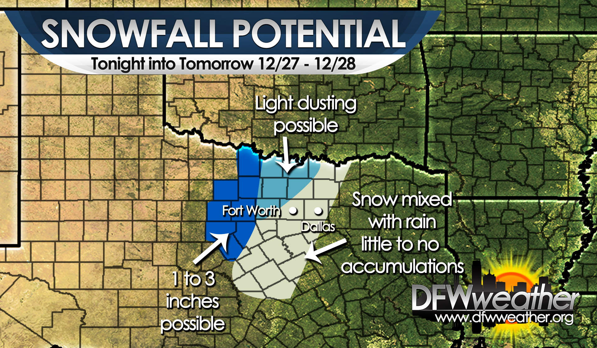
Snow will begin mixing with sleet and rain this evening across the areas shaded above. This graphic shows where we expect accumulations.
SEVERE WEATHER THREAT TODAY AND TONIGHT
As discussed, a powerful storm system will be affecting the area for the next couple of days. This storm system will be responsible for a variety of weather across the state, including a historic blizzard in West Texas to heavy rainfall and severe weather in our area. The Storm Prediction Center has placed our entire forecast area in an enhanced risk area for severe weather. Abundant moisture, indicative of dewpoints well into the 60s, very warm temperatures well into the 70s, will create convective instability around 2000 J/Kg. Combined with adequate shear, approaching cold front, and destabilization from storm system, the parameters are in place for severe weather across our area. The main threats will likely be heavy rainfall, but damaging winds and large hail will also be possible. In any discrete storms that can become rooted in the boundary layer may be able to spin up an isolated tornado. Most of the convection will be tied to a strong Arctic cold front that will move across the area and force the convection to take on a linear storm mode which should lessen the tornado threat. The cold front should be around DFW in the 10:00 PM to 12:00 AM timeframe. Behind this front much colder air will spread into the region lessening the severe weather threat.

Severe weather threat for December 26, 2015 as issued by the Storm Prediction Center.
CURRENT WATCHES AND WARNINGS ACROSS THE REGION
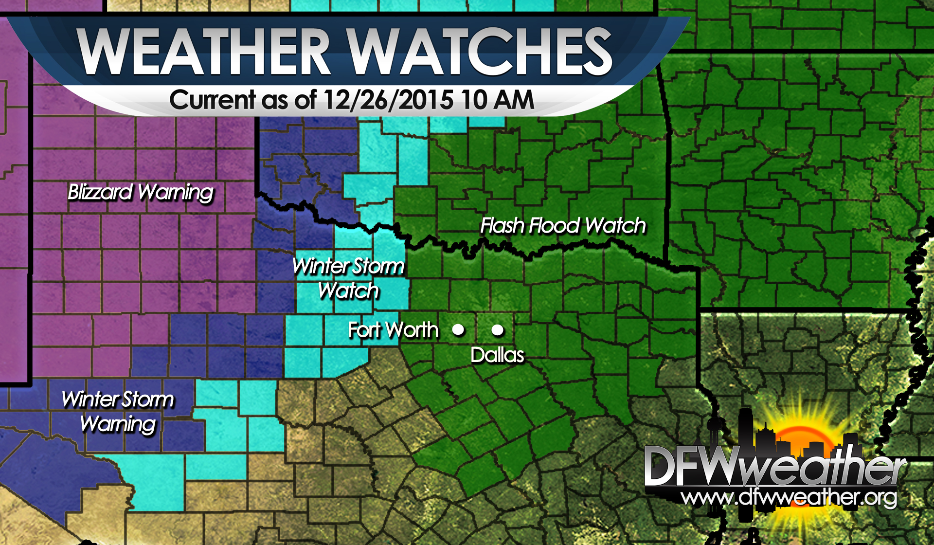
Current watches/warnings across the state as of 10:00 AM December 26, 2015.
Persons traveling across the Lone Star State should be aware of all the different watches and warnings posted as a powerful winter storm impacts the region. Residents of North Texas should be aware that the Winter Storm Watch has been expanded to just outside this website’s forecast area border. Accumulating snowfall will be possible in this area Sunday night. Wet snowflakes may fall as far east as the DFW Metroplex, though confidence in this is not high and highly depends on the track of the upper-level low and what dry slotting develops. Anyone traveling to West Texas should note that traveling in this region is strongly discouraged as a historical blizzard is going to take shape.
HEAVY RAIN EXPECTED TOMORROW INTO SUNDAY
As discussed yesterday, we are still expecting a heavy rain event to affect the area beginning tonight and lasting into Sunday. A Flash Flood Watch has already been issued for the entire forecast area by the National Weather Service office in Fort Worth. The graphic below depicts what we can expect in terms of rain amounts by the end of this event. On average, 3 to 6 inches of rain is expected across our area with locally higher amounts possible. This will only exacerbate the extraordinary rainfall received this year and flooding and flash flooding will be of major concern.
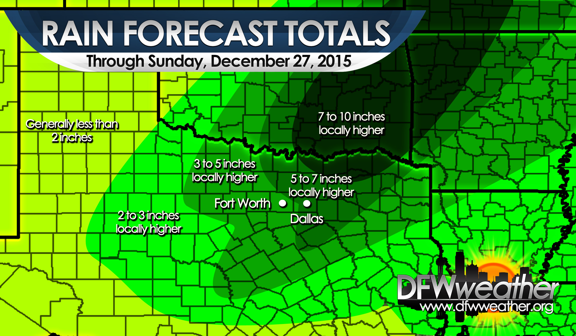
Post Christmas 2015 heavy rain event. Map depicts expected rain totals by the end of the event.
WINTER TO FINALLY ARRIVE IN NORTH TEXAS

Satellite image for December 24, 2015 depicting next potent upper-level storm system, to affect the area the weekend after Christmas, coming ashore in the Pacific northwest.
For those wanting a taste of winter, the exceptionally warm weather we have been experiencing for the last several weeks is about to come to an abrupt end. Unfortunately, this will not be in time for Christmas. Expect unseasonably warm conditions to persist the next couple of days.
A strong upper-level storm system is now entering the Pacific northwest. This will be our next major weather maker for not only us, but much of Texas as well. This system is expected to dig down into the desert southwest and strengthen and become a closed low. It will continue digging into northern Mexico, and then, swing east northeast across Texas over the post-Christmas weekend. A deep trough will envelop much of the Western CONUS and allow a big chunk of Arctic air to spill southward along the lee of the Rockies. This strong, Arctic cold front will begin moving across Texas on Saturday and reach the DFW area in the very early hours on Sunday morning while spreading a shallow, low-level Arctic airmass in its wake. The coldest air so far this season will follow the passage of this front and bring an abrupt end to our warm weather pattern.
Out ahead of the upper-low, strong southwest flow aloft and southerly flow at the surface will advect warm moisture laden air into the region. PWATs (precipitable water) will climb to the 99th percentile for late December across the area. What this means is the potential for another very heavy rainfall event for our area on Saturday into Sunday. It is too early to pinpoint exact amounts, but rest assured it does look like another multi-inch rain event for our area. This will promise to bring already extraordinary annual rainfall totals above the 60 inch mark for DFW. In addition to the heavy rainfall, areas east of the I-35 corridor will have the potential for severe weather with this system. Nearly all modes of severe weather will be possible. More details on the severe weather will unfold in coming days as we have a better idea of mesoscale parameters.
While we have rain in our area, much of west Texas will be experiencing what may become a historical blizzard for that region. Very heavy snowfall is expected in that part of the state with some potential for major accumulations. Near blizzard to blizzard conditions will be possible across much of West Texas from the Permian Basin into the Texas Panhandle. Winter Storm Watches have already begun posting for that part of the state. Travelers heading into that region should be extremely cautious of the weather and plan to make alternative travel plans.
The snow may begin to spread into the western half of North Texas Sunday night into Monday, as the cold air deepens in our area due to the track of the upper-low passing nearly over top of the area. Rain may begin to mix with or change to snow as far south as the DFW area during this time frame. This is all dependent on the exact tract of the low and where the dry slot sets up with this system. Any deviation to the northwest of the tract of the low will keep the cold air warm enough for the precipitation to remain all liquid in our area. If the low moves further south or southeast, then a changeover to all snow could produce some minor impacts to our area. Stay tuned as this part of the forecast could change significantly.
Lows by Tuesday morning will likely drop into the 20s most areas with temps struggling to make it into the 40s for Monday and Tuesday.
SEVERE WEATHER THREAT TODAY
A rather strong shortwave trough will approach the area this evening on a negative tilt providing lift for scattered convection across the area. The latest hi-res models are keeping most of the storms that fire with this disturbance east of the Metroplex, but there is a marginal threat for severe weather for any storms that can overcome the cap. For the Metroplex, the storms look to be mostly elevated limiting the severe weather threat, provided the cap can be breached. Strong to severe storms are possible with the main threats being damaging winds around 50 mph to 60 mph and moderate sized hail. As the storms push east, or further eastward development occurs, conditions are little more favorable for severe weather as the storms can become surface based. Adequate instability in the 1000 to 2000 J/Kg range and shear combined with lapse rates in the 6 to 7 C/km range leads to a slight risk area for severe weather. Storms will be able to produce damaging winds in excess of 60 mph, large hail, and pose an isolated tornado risk. This slight risk is noted in the orange color in the map below and should mostly be east of the Metroplex. As this disturbance races off to the northeast, the threat for storms will diminish after 3 am.
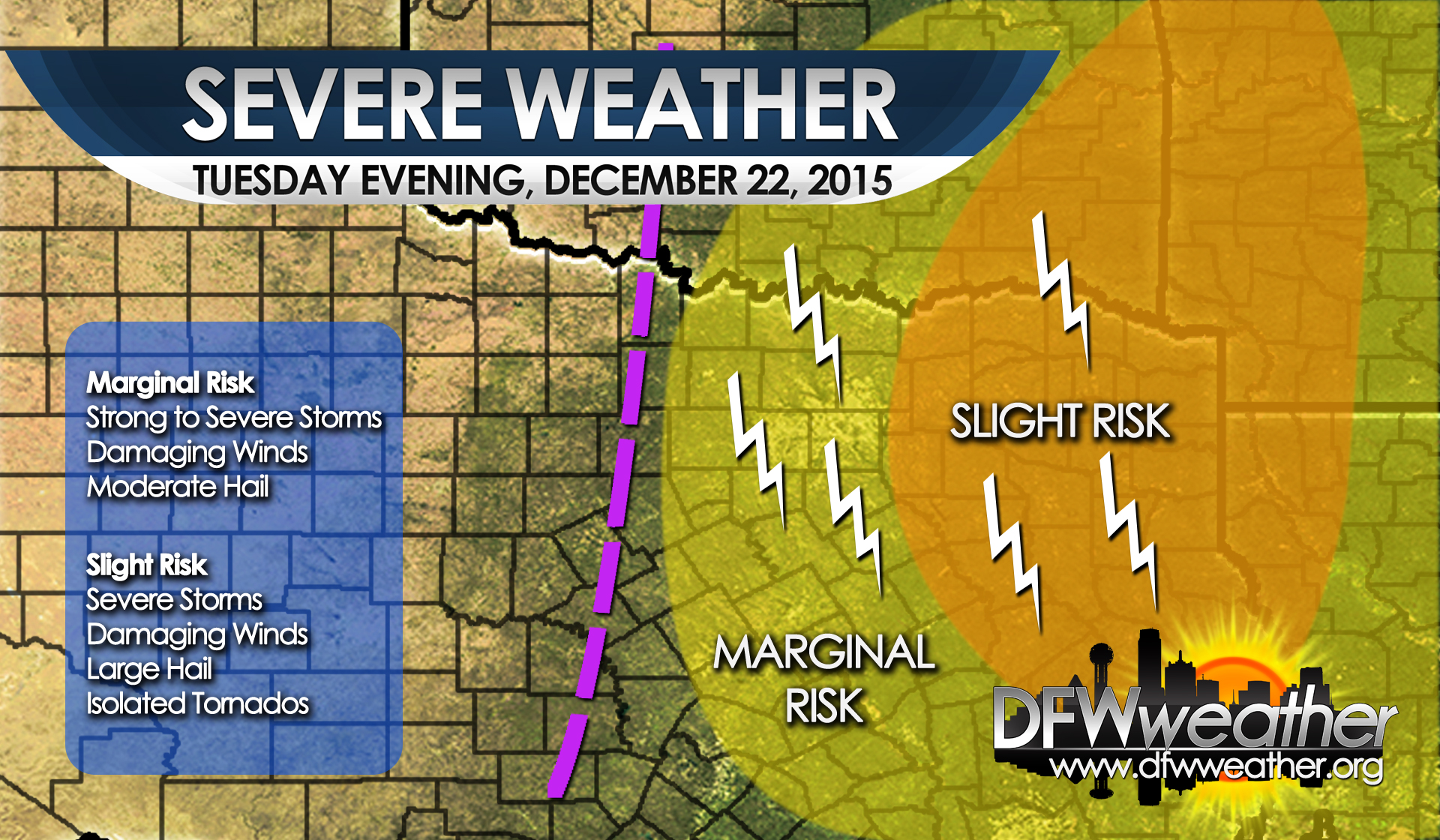
Severe weather threat for Tuesday evening, December 22, 2105
POST CHRISTMAS 2015 STORM TO BRING ANOTHER ROUND OF RAIN TO THE AREA

Stubborn pattern over the United States that has what cold is available in the west and warmth for the eastern half of the country. This pattern has been dominant for much of December and will continue through Christmas with near record heat in some places.
For those hoping to see some actual winter weather or temperatures this year for Christmas are going to be very disappointed. Temperatures well above normal will be the rule this week as with much of December 2015. In fact, December 2015 is in the running of being the all time hottest December on record for DFW. As has been the case this year, intense southern stream storm systems have brought copious amounts of rains to the area. It looks like the storm system we are watching post Christmas will be no different.
In the meantime, there a couple of smaller features to discuss in the short-term. Today, a weak cold front will push the soupier air and fog from this morning southeastward as it sweeps across the area. This will allow clouds to clear and temperatures to fall into the 40s overnight (still well above normal for this time of year). Tomorrow morning will likely be the coolest morning of the week. The radiational cooling setup tonight combined with light winds and lingering moisture will set the stage for the potential for fog tonight after midnight. Some of this fog could be dense and may take sometime Tuesday morning to burn off.
A weak short wave trough will dive out of the Rockies into the Central Plains Tuesday and rapidly intensify. This will draw the soupier air back over DFW by Tuesday afternoon, setting the stage for scattered convection from the I-35 corridor points eastward by early Tuesday evening. The official forecast will carry POPs at 20 percent to account for any storms. Any storms that form will have the potential to become strong to even severe as 1000 to 2000 J/Kg of CAPE can be realized by Tuesday evening across the area. Any severe storms would be capable of damaging winds and the threat of moderate to large hail. An isolated tornado threat cannot be entirely ruled out east of the Metroplex, but the tornado threat looks low. Storms will quickly move eastward as the shortwave lifts northeast away from the region.
In its wake, southwest flow aloft will dominate out ahead of potent storm system that moves onto the Pacific northwest. This system is expected to dive into the desert southwest and intensify while becoming partially closed off. The computer models diverge substantially in the handling of this system, but it looks like it will be our next big storm system post Christmas. Warm air advection showers will begin to break out across the area as early as Christmas Day afternoon. This system will have a good fetch of moisture to work with, given the long stretch of southerly flow ahead of it, bringing with it a potential for heavy rainfall as a rather strong cold front dives in from the north on Saturday. It is too soon to tell how much rain we will get, but it does look like at least enough to send us over the 60 inch mark at DFW for the year. This system will need to be watched closely for heavy rainfall leading to more flooding problems and if the precipitation shuts off before the significantly colder air arrives. Stay tuned for inevitable updates to this forecast as the week progresses.