
The coldest Halloween in 26 years just occurred at DFW. It was 1993 when we had a cold blast of similar magnitude to the one that just happened. In fact, the cold blast of 1993 was actually a little colder and produced snow flurries on the 29th. On Halloween 1993, we reached a low of 29°F. This year we missed that record by one degree with the low on Halloween reaching 30°F. We tied the record low of 31°F set in 1906 for November 1st. 2019 was only one of five years where we had back-to-back consecutive freezes so early in the season. Other years with back-to-back freezes so early in the season include, 1913, 1925, 1957, 1993, and 2019. October 2019 ended up being 2 degrees below normal for the month. This joins the myriad of cooler than normal months of 2019, with September 2019 being the notable exception because it was the hottest September on record.
Category Archives: News
WE FALL BACK ONE HOUR THIS SUNDAY, NOVEMBER 3, 2019
Just a reminder that we fall back one hour at 2:00 am, Sunday, November 3, 2019. Central Daylight-Savings Time (CDT) ends and we begin Central Standard Time (CST). Remember to set your clocks back one hour.
9 CONFIRMED TORNADOES HIT THE METROPLEX LAST SUNDAY, OCTOBER 20, 2019
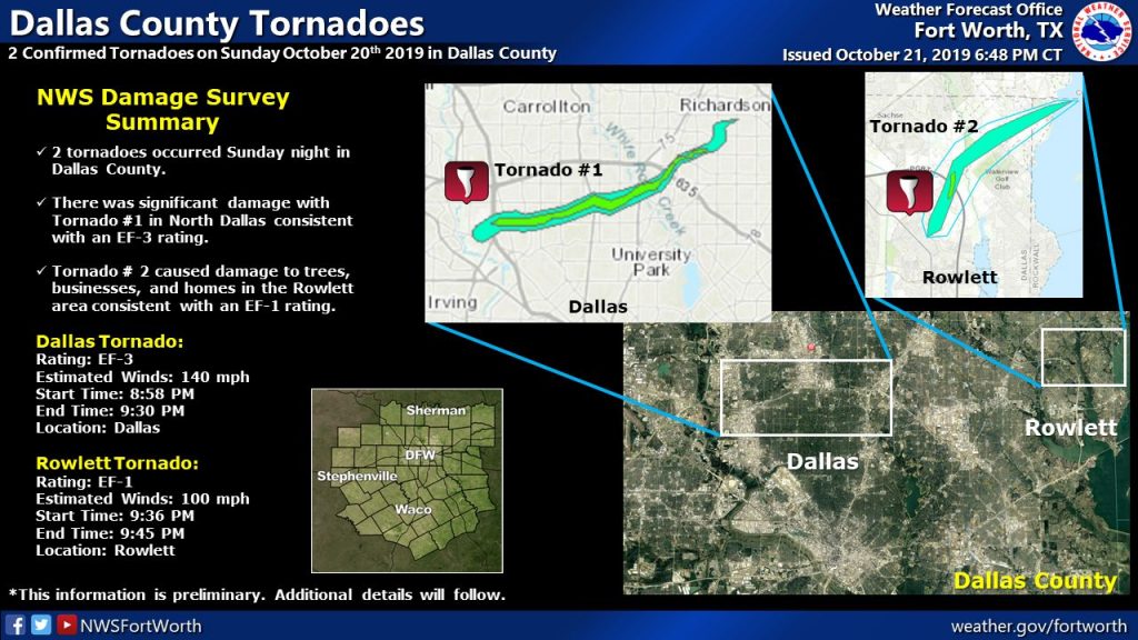
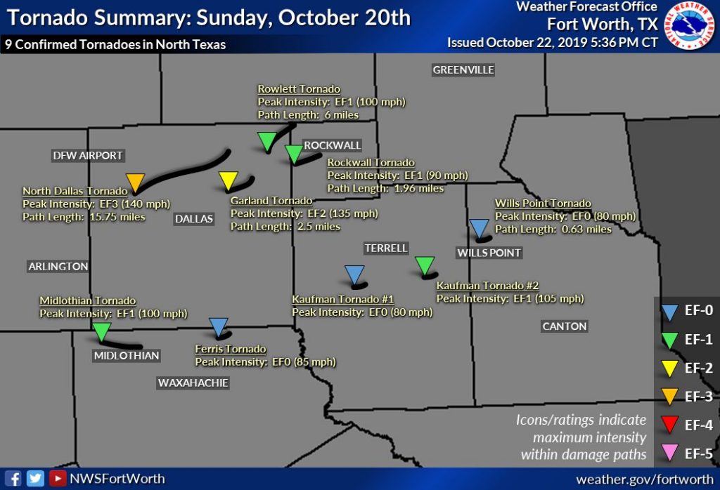
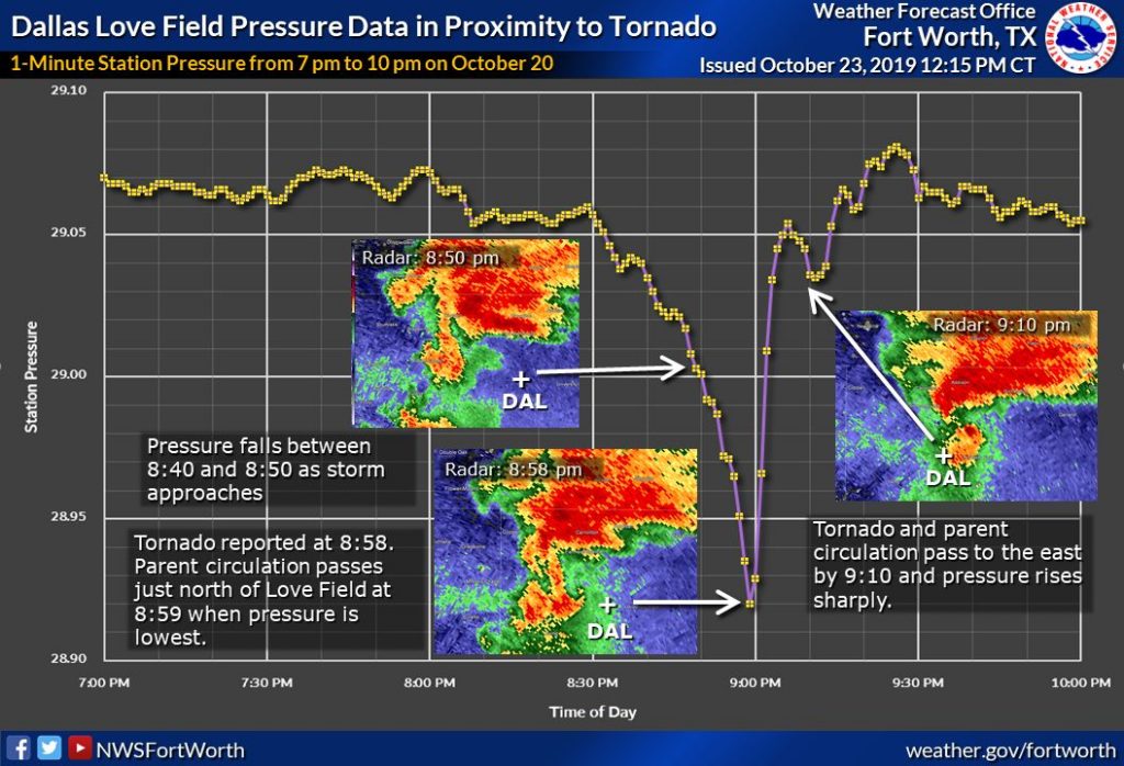
The National Weather Service office in Fort Worth has confirmed that 9 tornadoes hit the Metroplex last Sunday, October 20, 2019. The strongest and most devastating of which was the Dallas Tornado:
- Rating: EF-3
- Winds: 140 mph
- Start Time: 8:58pm
- End Time: 9:30pm
- Track: 15.75 miles
Other tornadoes touched down in Rowlett, Midlothian, Ferris, 2 in Kaufman County, Garland, Rockwall, and Wills Point. The one that hit Dallas was among the strongest to ever hit the city of Dallas. Below are preliminary results and graphics from the National Weather Service.
DFW SETS A RECORD HIGH TEMPERATURE YESTERDAY, OCTOBER 6TH
A record high temperature of 97°F was set at DFW Airport
yesterday, October 6th. This breaks the old record of 96°F set in 1956.
SEPTEMBER 2019 THE HOTTEST AND DRIEST ON RECORD FOR DFW
September 2019 is the hottest and driest on record for DFW as officially recorded at DFW Airport. Records date all the way back to September 1898 (121 years). The average temperature for September 2019 was 86°F. The normal average temperature for September should be around 78°F. We had the most 95°F and 90°F days than any September on record (23 and 29 days respectively). This is the only September where no low temperature below 70°F was recorded. To put that in perspective, 60% of Septembers should see at least one low temp below 60°F with about 25% seeing a low of 50°F or below. When the low temperature stays 60°F or above, that is a bit of a benchmark for a warm September.
Additionally, September 2019 is the only September on record not recording any measurable rainfall, making it the driest on record. What a difference a year makes! September 2018 was the wettest on record for DFW where 12.69 inches of rain fell.
Below are the top 5 hottest and coldest Septembers for DFW and their respective average temperatures.
HOTTEST:
- 2019 – 86°F
- 2005 – 84°F
- 1939 – 84°F
- 1998 – 84°F
- 2015 – 83°F
COLDEST:
- 1974 – 71°F
- 1902 – 73°F
- 1918 – 73°F
- 1913 – 73°F
- 1935 – 74°F
DFW REACHES 100°F OFFICIALLY FOR THE FIRST TIME THIS SUMMER SEASON
Yesterday, July 30, 2019, the high temperature hit 100°F. This marks the first official 100 degree day for the 2019 summer season at DFW. By no means a record late first 100 degree day (that is in Septemeber), but it is quite rare for us to go all of June and most of July without hitting 100°F. There are only two years on record where we did not hit 100°F at all, that is the summers of 1906 and 1973.
RECORD DAILY RAINFALL AT DFW YESTERDAY
DFW Airport recorded 2.42 inches of rain on Sunday, June 16, 2019. This breaks the old record of rain for that date
of 1.32 inches which was previously set in 1968.DFW SETS A RECORD LOW MAX TEMPERATURE YESTERDAY
The high temperature yesterday, May 10, 2019, at DFW Airport was 57°F. This
breaks the record for the lowest maximum temperature for May 10th of 63°F
previously set in 1954.
SIGNIFICANT SEVERE WEATHER OUTBREAK EXPECTED TODAY LATE AFTERNOON WELL INTO THE EVENING
A potentially significant severe weather episode is unfolding for the forecast area later this afternoon well into this evening. The Storm Prediction Center has placed the entire forecast area in the Enhanced Risk category for severe weather. Please see the map below. The Enhanced Risk area is in orange, the Slight Risk area is in yellow, the Marginal Risk area is in dark green, the lighter green area means non-severe convection is possible.
Setup: A powerful upper level trough will be digging into the western portions of the state. A dryline will setup ahead of this system and begin surging eastward. Copious moisture advection from the Gulf will be pulled northward, indicative of dewpoints surging into the upper 60s/70s. CAPE (convective available potential energy) values in this moisture laden, warm atmosphere will climb to around 3000 to 3500 J/Kg with shear in excess of 50 knots.
What to Expect: Discrete cells should begin firing along and ahead of the dryline and possibly as far east as the I-35 corridor late this afternoon. These will rapidly become severe producing gigantic sized hail in the Enhanced Risk area. It will be possible for hail to reach baseball, or even softball, size in this type of environment. Over time these cells should grow into a QLCS (quasi-linear convective system) and push eastward with an attendant damaging straight-line wind threat. With the discrete supercells, especially ahead of the dryline, a few tornadoes cannot be ruled out. The tornado threat should wane as the storms form into QLCS. Another line of storms may approach the area later tonight along the actual cold front.
When: Wednesday, April 17, 2019 between 5:00pm and Midnight.
Please stay alert to changing weather conditions and heed any possible warnings that may be issued for your location.
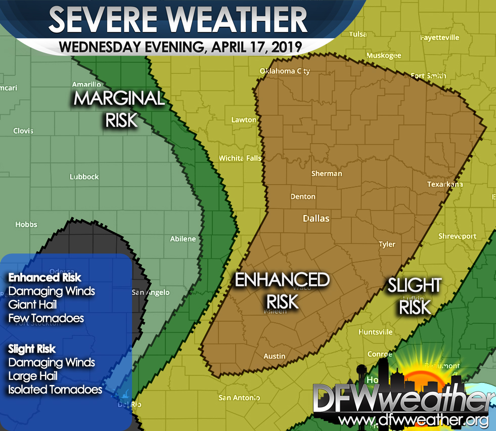
Storm Prediction Center severe weather outlook for Wednesday, April 17, 2019. Damaging winds, giant hail, and a few tornadoes are possible in the Enhanced Risk area which covers the entire forecast area.
2018 SECOND WETTEST YEAR ON RECORD FOR DFW
2018 closed out as officially being the second wettest year on record for Dallas/Fort Worth as recorded at DFW Airport. Out of 120 years of weather records, 2015 and 2018 are the wettest on record. In addition, 2018 produced three months that recorded all time rain records, February (11.31 inches), September (12.69 inches), and October (15.66 inches). A statistic like that will likely never occur again your lifetime. Below are the top five wettest years for DFW:
- 2015 – 62.61 inches
- 2018 – 55.97 inches
- 1991 – 53.54 inches
- 1932 – 51.03 inches
- 1973 – 50.62 inches.
For reference, the average annual rainfall at DFW is 36.14 inches.