Category Archives: News

WINTER STORM WARNING – HISTORIC WINTER STORM – DANGEROUSLY SEVERE COLD

Key Messages:

  • Winter Storm Warning in effect until Monday for the entire forecast area
  • Snow accumulations 3 to 7 inches with possible higher snow drifts
  • Temps plunging to near all-time record cold temps on Tuesday with lows near 0°F
  • Windchill values 10 to 20 below zero
  • Hypothermia and frostbite can set in quickly in this type of dangerous/severe cold
  • This will be the coldest in 30 plus years!
  • This will be a prolonged cold snap
  • Temps will not get above freezing until next Saturday
  • Blowing and drifting snow
  • Near Blizzard conditions at times Sunday night
  • Whiteout conditions possible Sunday night
  • Travel becoming treacherous to impossible for all of the coming week
  • Major damage to infrastructure and agriculture from the cold
  • Another major winter storm expected Tuesday night into Thursday
  • Governor Abbott has declared all of Texas as a disaster area

Folks—we cannot stress this enough—you are about to witness a historic winter weather event. It cannot possibly get any more severe than this. This will rival the great cold air outbreaks of December 1989, December 1983, January 1930, and yes the king of them all February 1899. This will be a protracted cold snap. DFW Airport has already spent the last 72 hours below freezing and counting. We are not expected to rise above freezing until next Saturday afternoon at the earliest. This will make for the longest stretch of subfreezing conditions at DFW since December 1983. Major agricultural and infrastructure damage will result from such cold. Governor Abbott has issued a disaster declaration for all of the state of Texas. You have narrow window today to do final preparations before things deteriorate rapidly.

Areas of freezing drizzle this morning are coating surfaces, including roadways with a thin glaze of ice. Motorists are urged to exercise extreme caution this morning if traveling. The freezing drizzle should end this afternoon, with a lull before the next precipitation starts this evening as the main shortwave trough approaches Texas. Areas of freezing drizzle and sleet will begin tonight and ramp up significantly after sunrise on Sunday. The ground surface is frozen after 72 hours and going on 96 hours of subfreezing temperatures at DFW Airport. This means precipitation will stick instantly as it falls to the ground causing roads to deteriorate rapidly on onset. Snow will become widespread and heavy Sunday night. Because of the powdery nature of the snow, much like you would find at a ski resort, it will easily be blown around. Winds are expected to be near 30 mph at times causing blowing and drifting of snow and near blizzard conditions at times. Visibilities will be reduced to near 0 at times causing whiteout conditions. It is strongly recommended that no one travel during this time. Snow ratios may be 15:1 to 20:1 as opposed to our typical 10:1 because of the extreme cold. Total accumulations expected are 3 to 7 inches. Snow drifts could easily exceed 7 inches. It must be stressed that not everyone will see 7 inches and some places could exceed 7 inches, and some places could be a little less than 3 inches. However, everyone should see at least 2 inches of snow.

On top of all of this a frigid Arctic airmass will continue to be advected south. We are dealing with, as stated above, the coldest weather DFW has seen in 30+ years. Temperatures will be close to 0°F by Tuesday morning. Breaking the daily low temperature record and getting near the all-time low temperature record for DFW of -8°F set on February 12, 1899, though that should be safe. We have already gone 72 hours at DFW Airport below freezing. We are not expected to rise above freezing until next Saturday afternoon at the earliest. This will be the second longest stretch of subfreezing conditions ever recorded. The record is December 1983 with 12 days of subfreezing conditions. This is life-threatening cold we are talking about. Frostbite and hypothermia can set in quickly in this type of cold. Hard Freeze Warnings and Wind Chill Warnings will likely be necessary.

Precautions should be completed today to protect people, pets, livestock, and exposed pipes. This type of prolonged cold will cause extensive damage to infrastructure and agriculture locally and across the state. Pipes can freeze and burst in such extreme cold.

WINTER WEATHER ADVISORY – COLDEST AIR IN DECADES FOR DFW

UPDATE: The Winter Weather Advisory has been expanded to include all of the forecast area. The expectation is the precipitation will be a bit heavier tonight in the form of actual freezing rain and sleet. Ice accretion in the advisory area is expected to be up to 1/4 of an inch with isolated amounts slightly higher. Since amounts reaching 1/4 of an inch will be more isolated, they have foregone a Winter Storm Warning at this time. Regardless, this will be enough ice to cause problems on not only bridges and overpasses but secondary roadways as well. Thursday morning commutes could be very problematic. Temperatures are expected to be in the 24-28°F degree range in the advisory area. DFW Airport forecasted low is 25°F.

Temperatures dropped to the middle to upper 20s, a couple of degrees colder than most models, this morning across the Winter Weather Advisory area which was expanded to include Dallas and Tarrant Counties. Widespread freezing drizzle has been occurring. Motorists should exercise caution when commuting this morning for possible icy bridges and overpasses and black ice patches. The advisory now runs through noon on Thursday as another disturbance pivots across the area bringing more in the way of light freezing rain and sleet tonight into tomorrow. Temperatures should have no trouble getting into the mid 20s again tomorrow morning. Areas that fall below 28°F may have more widespread issues with all roadways.

We will continue to see one Arctic surge after another through the coming 7 days. The coldest of which will occur on Saturday night through Wednesday. There is confidence that we, at some point at DFW Airport, will get to 12°F or colder, which will make for the coldest temps since 1996. If the mercury reaches 7°F, it will be the coldest since December 1989. Regardless of how cold it actually gets, it does look like temps will reach severe cold category with dangerously cold wind chills approaching 10 below zero at times. Hard Freeze Warnings and Wind Chill Warnings will likely be needed at some point.

There will be a quick shot of sleet and snow with the Arctic front on Saturday. However, it will get shut off rapidly by the deepening cold air. Models are now coming into better agreement on a more significant winter storm (likely all snow) Sunday night into Monday. If we get a snowpack, it will only exacerbate the bitterly cold temperatures. This is still several days out and the forecast will likely undergo many changes. More on this potential as more data becomes available.

MAJOR COLD AIR OUTBREAK (POSSIBLE SEVERE COLD) THIS WEEKEND AT DFW

A massive Arctic airmass has been building in Canada and has been the focus for the last several days in the weather community. The question was when and if it would move south. The models have come into nearly unanimous agreement this air will move south this week. The worst and core of the cold may move over Texas this weekend bringing some of the coldest temperatures in years to DFW (at least since January 2018, but maybe longer if the models are to be believed). A cursory glance shows most of the central and western Canadian prairies well below zero (-40°F+ in some areas). With an upper low tightening up in the Great Lakes, the flow around this will be enough to give the airmass the nudge to move south rapidly in waves by the weekend.

The leading edge of this massive Arctic air is actually going to move into the area tomorrow, kind of like pancake batter, moving south based on its own density. This is a very shallow leading edge of the Arctic airmass and really not all that cold yet. Our temperatures will gradually turn colder throughout the week with the coldest arriving Friday evening and may last into early next week.

Severe cold is defined at DFW as being a low temperature at or below 10°F or a high at or below 20°F. This is definitely on the table with several models showing that kind of cold. While we are not confident, yet, in cold getting that extreme, we are confident it will turn very, very cold. Temps will likely drop into the teens, if not colder, and wind chills may dip below zero at times. This is also likely to be a protracted cold spell much like Super Bowl week of February 2011. We could see more than a day of subfreezing temperatures.

What is not quite as clear is the prospects of precipitation in the cold air. Experience tells us moisture may be hard to realize in such deep intrusions of cold air. However, it does not take much lift or moisture to cause it to precipitate in that kind of cold air, and their will be some perturbations that move across the cold air. Of course any precipitation in this cold would be frozen and could potentially impact travel. More on this as we get a better handle on the latest data.

Residents of DFW should prepare now to insulate exposed outdoor pipes from the cold. If this cold is realized to its full potential, it would be more than enough to freeze and burst pipes that are exposed.

SEPTEMBER 2020 THE 13TH COOLEST SEPTEMBER ON RECORD FOR DFW

September 2020 turned out to be the 13th coolest September on record for DFW with an average monthly temperature of 75°F. We were 3.3°F below normal for the month. The coolest temperature of 50°F was recorded on September 29th, only 10°F above the all-time coldest monthly low of 40°F. Pretty impressive considering that only last year, September 2019, was the all-time hottest September on record for DFW. Weather records date back 122 years to September 1898 for the DFW area.

RECORD HEAT AT DFW YESTERDAY AND TODAY

DFW Airport shattered the high temperature record for April 8, 2020. The high temperature of 97°F breaks the old record high of 93°F set in 1991.

In addition, the low temperature this morning, April 9, 2020, was 71°F breaking the old low maximum temperature of 70°F set in 2001.

SIGNIFICANT SEVERE WEATHER POSSIBLE TODAY WITH TORNADOES

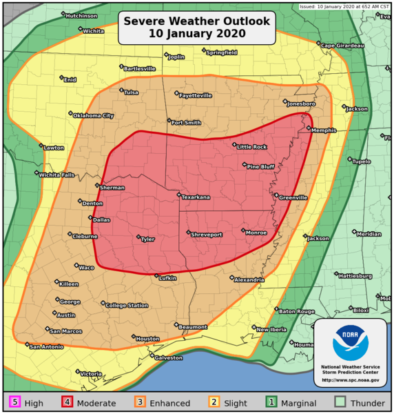
WHAT: The atmospheric ingredients are coming together for a potential significant severe weather event today, and possibly a significant tornado outbreak across the area. All modes of severe weather are possible, including tornadoes, hail to the size of baseballs, and damaging straight-line winds. The Storm Prediction Center has placed part of the area in a Moderate Risk category for severe weather, the rest of the area in an Enhanced Risk category. The potential for strong and violent tornadoes also does exist in this type of setup. If a tornado warning is issued for your area, please heed the warning.

WHEN: Today between Noon and 9pm

WHERE: The entire forecast area.

RECORD COLD CLOSES OUT OCTOBER 2019 AT DFW

The coldest Halloween in 26 years just occurred at DFW. It was 1993 when we had a cold blast of similar magnitude to the one that just happened. In fact, the cold blast of 1993 was actually a little colder and produced snow flurries on the 29th. On Halloween 1993, we reached a low of 29°F. This year we missed that record by one degree with the low on Halloween reaching 30°F. We tied the record low of 31°F set in 1906 for November 1st. 2019 was only one of five years where we had back-to-back consecutive freezes so early in the season. Other years with back-to-back freezes so early in the season include, 1913, 1925, 1957, 1993, and 2019. October 2019 ended up being 2 degrees below normal for the month. This joins the myriad of cooler than normal months of 2019, with September 2019 being the notable exception because it was the hottest September on record.

9 CONFIRMED TORNADOES HIT THE METROPLEX LAST SUNDAY, OCTOBER 20, 2019

The National Weather Service office in Fort Worth has confirmed that 9 tornadoes hit the Metroplex last Sunday, October 20, 2019. The strongest and most devastating of which was the Dallas Tornado:

  • Rating: EF-3
  • Winds: 140 mph
  • Start Time: 8:58pm
  • End Time: 9:30pm
  • Track: 15.75 miles

Other tornadoes touched down in Rowlett, Midlothian, Ferris, 2 in Kaufman County, Garland, Rockwall, and Wills Point. The one that hit Dallas was among the strongest to ever hit the city of Dallas. Below are preliminary results and graphics from the National Weather Service.