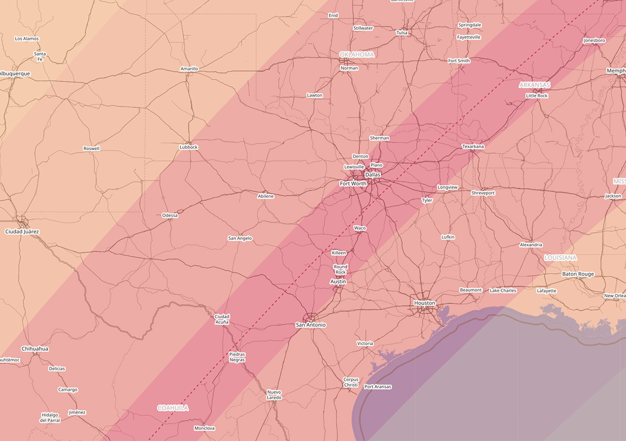
MAJOR ARCTIC AIR WITH THREAT FOR SEVERE COLD FOR THE MLK WEEKEND

DFW’s mild winter is about to come to an end. A very impressive Arctic airmass will be building and plunged south into the heartland of the CONUS over the weekend, indicative of a ~1045mb high pressure system. This all teleconnected very well with negative EPO, negative WPO, negative AO, and negative NAO. This will produce the coldest weather for this winter by a long shot for DFW. There is an increasing concern that temps could fall below 10°F at the coldest point which is the threshold for severe cold for this region and necessitate Hard Freeze Warnings for the area. This type of cold can damage agriculture and infrastructure this far south as we saw in February 2021. At the very least, we are confident temps will fall to the teens Monday and Tuesday next week for DFW with high temps struggling to get out of the 20s. At this time, it is not anticipated that the cold will be anywhere near the magnitude of February 2021, or last as long. There is a small chance that we may see some impactful wintry precipitation Sunday night into Monday. Not all of the models are on board with this scenario, but enough are that we will be monitoring that closely. Of course, any frozen precipitation will only exacerbate the cold. If you have not winterized your homes, now will be a good time to do so.

DFW OFFICIALLY HITS 110°F FOR THE FIRST TIME IN 12 YEARS WHICH IS EXCEPTIONALLY RARE

Yesterday, the temperature at DFW Airport climbed to a whopping 110°F. The last time this happened was during the hot summer of 2011. Before that, you have to go back to the summer of 2000. This is exceptionally rare, and conditions have to be just right for it to occur. Out of 124 years of weather records, we have only hit the 110°F mark or greater 12 other times. Five of those times occurred during the record breaking summer of 1980. Statistically, this is about a once in a decade occurrence. The hottest DFW has ever been was during June of 1980 when the mercury hit 113°F. Below is table of all the occurrences of temperatures of 110°F or greater in the DFW weather records:

UPDATE: The summer of 2023 now becomes the second year to have more than one day with a temperature at or above 110°F. Yesterday, August 26, 2023 DFW Airport set a record high of 110°F which also broke the daily record. The only other year to have multiple days at or above 110°F was the summer of 1980 (which had 5), as you can see below. This also pushes our tally of a total of 14 – 110°F degree days over our entire weather records history.

DATETEMP IN °F
6/26/1980113
6/27/1980 113
8/11/1936112
8/18/1909112
6/28/1980112
9/4/2000111
8/2/2011110
8/10/1936110
8/16/1943110
8/25/2023110
7/12/1998110
7/2/1980110
7/18/1980110
8/26/2023110

HOURS BELOW FREEZING LAST WEEK

During last week’s wintry weather, some locations remained at or below freezing for more than 100 hours. Hearne rose above freezing during each day of the event, but Granbury remained at or below freezing from late Sunday (January 29) until early Friday (February 3), a total of 111 consecutive hours. Officially at DFW Airport, the total number of consecutive hours below freezing was 88 hours. The all time record number of consecutive hours spent below freezing for the DFW Metroplex is 295 hours from 7:00 am December 18, 1983 to 2:00 pm December 30, 1983.

SEVERE ICE STORM UNFOLDING FOR THE WESTERN PART OF THE METROPLEX

The National Weather Service office in Fort Worth is upgrading the Winter Storm Warning to an Ice Storm Warning for the western half of the Metroplex including Fort Worth for tomorrow into early Thursday. The potential exists for severe icing on top of the already 1/2 inch of sleet or so. There could be an additional 1/2 inch of ice accretion from moderate to heavy freezing rain tomorrow. This would make travel nearly impossible and hamper the improvement of roadways in this area until late Thursday or early Friday. This amount of ice could potentially cause widespread power outages, especially in areas that have above ground power lines. The weight of the ice can bring them down, and also bring down tree limbs that fall on the power lines. Travel in Tarrant, Parker, Hood, Denton, Johnson, and Wise counties is strongly discouraged.

ICE STORM TAKING SHAPE FOR DFW FOR MONDAY THROUGH WEDNESDAY

An Acrtic airmass is barreling south and should reach the DFW Metroplex by sunrise Sunday morning. Temperatures should plummet 10 to 20 degrees with a an hour or so behind the front. Sunday’s high temperatures are occuring now. This airmass is very dense but shallow, only about 1 km thick vertically. It will also hang around most of the upcoming week.

As cold air advection intensifies Sunday evening, temperatures will drop below freezing all the way to Waco Monday morning. An upper level storm system will approach from out west setting the stage for freezing drizzle on Monday. This will start the icing process on bridges and overpasses. Because it is drizzle, roads may look fine, but are actually coated with a glaze of black ice. Motorists should be very cautious traveling on Monday.

Conditions will worsen Monday night into Tuesday as temperatures get colder and precipitation ramps up. Sleet will also be mixing in with the freezing rain. Total ice accretion from this event depends on several factors and not entirely known at this time. However, it is becoming clear that ice may cause major travel headaches from the DFW Metroplex north and west. There may be enough ice accretion to warrant a Winter Storm Warning for part or all of the forecast area. Please stay alert to changing weather forecasts and conditions.

RECORD HEAT AT DFW YESTERDAY AND TODAY

The official high yesterday was 83°F at DFW Airport. This broke the old record of 79°F set in 2017.

Expect similar conditions again today as temperatures soar into the lower 80s ahead of a rather strong cold front. Tomorrow temperatures will be some 25 degrees cooler. Thus the record high of 83°F set in 1911 will be in jeopardy of being tied or broken.

UPDATE: The record of 83°F set in 1911 for January 11th was in fact broken yesterday as the temperature officially hit 85°F at DFW Airport.

The hottest January temperature ever recorded was 93°F set on January 31, 1911.

SEVERE COLD EXPECTED THIS CHRISTMAS AT DFW

Key Messages:

  • Severe cold Arctic outbreak expected for Christmas. Arctic front arrives early Thursday.
  • Very cold temperatures with lows in the single digits both Friday and Saturday mornings.
  • Wind chill values will be below zero Thursday night into Friday morning.
  • Very strong winds expected on Thursday behind the front.
  • No snow or ice is expected outside of a few flurries.
  • Temperatures to stay below freezing for 72 hours (from Thursday to Christmas Day)
  • Pipes will burst if not properly wrapped and protected
  • This will be the coldest Christmas since 1989.

A major Arctic airmass that has been building in Canada seeded by air from Siberia will plunge southward into the lower 48 this week. The high pressure associated with this airmass is progged to be some 1060+ mb and may challenge high pressure records for the lower 48. This will undoubtedly bring a severe cold snap to much of Texas for the holiday. Residents, especially those planning on being out of town, should prepare their homes by wrapping their pipes. Temperatures at the coldest point could potentially reach the upper single digits at DFW. This is cold enough to cause infrastructure damage in this region and is considered severe cold. Freezes will likely reach all the way into Northern Mexico and into the Lower Rio Grande Valley with this.

The Arctic front is expected to arrive on very early Thursday with plunging temperatures behind it. Temps will likely be in the single digits across all of North Texas by Friday morning with wind chills below zero. This will not be a repeat of the cold air outbreaks of December 1983, December 1989, or most recently, February 2021. We simply will not get that cold, nor is the longevity of this cold air outbreak expected to be that long. However, this will be the coldest Christmas since 1989 for DFW. Freezing temperatures are expected for about 72 hours from Thursday to Christmas Day. We are not expecting any ice or snow with this cold outbreak at this time. Residents are urged to take proper precations to winterize their homes, including wrapping exposed outdoor pipes. Pipes will freeze and burst in this type of cold.

SUMMER 2022 THE 4TH HOTTEST ON RECORD FOR DFW

Summer 2022 came in as the fourth hottest on record officially for DFW. The average temperature was 88.2°F for the three month period beginning June 1st through August 31st. We had a total of 47 days of 100°F heat. 21 of those days were consecutive from July 16th through August 5th. The first 100-degree day of the summer was 103°F on June 11th. The last 100-degree day was 102°F on August 17th. The average number of 100-degree days per summer season is about 16. The hottest temperature of the summer was 109°F that occurred three consecutive days on July 18th through the 20th. The coolest temperature of the summer was 65°F on June 2nd.

The top five hottest summers on record for DFW with their average temperature are as follows:

  1. 2011 90.5°F with 71 100-degree days
  2. 1980 89.2°F with 69 100-degree days
  3. 1998 88.3°F with 56 100-degree days
  4. 2022 88.2°F with 47 100-degree days
  5. 1954 87.7°F with 52 100-degree days

AUGUST 2022 THE WETTEST AUGUST ON RECORD FOR DFW

The extraordinary rain event we have had this week has broken many records for DFW. Officially, we are now the wettest August ever recorded at DFW Airport with 10.38 inches of rain so far this month. This breaks the old monthly record of 10.33 inches set in August of 1915.

The daily rain record for both August 21st and 22nd were shattered. We recorded 3.53 inches of rain on August 21st, which broke the old daily record of 2.25 inches set in 1919. For August 22nd, we officially recorded 5.66 inches of rain, which broke the old record of 2.47 inches set in 1916.

The 24-hour period of rain that we received beginning on August 21st and ending August 22nd was the second rainiest 24-hour period on record with a total of 9.19 inches of rain. The most rain ever received in a 24-hour period was 9.57 inches of rain on September 4th and 5th of 1932.

SUMMER 2022 RECORD HEAT AT DFW

DFW set a record high yesterday, July 20, 2022 and also tied the maximum low temperature record for that date. DFW also set a record high temperature on July 19, 2022 and also tied the maximum low temperature record for that date. DFW also tied the all-time maximum low temperature record for July 18, 2022 while also breaking the daily record for that date.

The temperature yesterday reached a high of 109°F, for the third consecutive day, which broke the old record of 108°F set in 2018. DFW tied the low temperature maximum of 82°F set in 1954.

The temperature on July 19, 2022 reached a high of 109°F which broke the old record of 108°F set in 2018. DFW tied the low temperature maximum of 84°F set in 1980.

The low temperature on July 18, 2022 was only 86°F. This tied the all-time lowest maximum low temperature ever recorded at DFW set several times, but most recently in 2018. This also broke the daily maximum low temperature record of 83°F set in 2018.

DFW temperature records are observed at Dallas/Fort Worth Interantional Airport weather station, station ID, KDFW.