
Don’t get too comfortable with the brief early glimpse of fall that we experienced over the past weekend, where morning temperatures fell into the 50s and lower 60s across the forecast area on Sunday coupled with a dramatic decrease in humidity levels. Winds will abruptly and vigorously turn back to the south in response to a deepening low pressure system ejecting out of the Rockies onto the Northern Plains. This system will have little impact on our sensible weather, but the increase in southerly wind speeds will advect Gulf moisture back into the area. As temperatures warm back to and above seasonal normal values (89°F normal high for this time of year), heat index values will also soar back to above the century mark by the end of the week, thanks to the increase in humidity. A weak cold front will approach the area by the end of the week with perhaps a few spotty showers and thunderstorms along the Red River. This will be something to watch because if the front sinks farther south, then our chances locally increase for isolated showers and thunderstorms. Though the summer heat will try to make a valiant comeback, at this time, there does not appear to be any sign, aside from the heat index, of triple digit ambient air temperatures. Not too much longer to go before it will be impossible for triple digit heat to occur until next year. Thus, the clock is really winding down fast on summer…
Author Archives: dfwwea5
SIGNS THE SEASONS ARE A CHANGING
A significant upper-air pattern change is going to take place this week across the CONUS that will have direct impacts on the sensible weather for North Texas. A series of shortwaves will carve out a substantial trough in the center of the CONUS this week, helping to break down the upper-ridge that is currently sitting on top of Texas over the holiday weekend. This ridge will ensure temperatures stay in the upper 90s to near 100°F through the middle of next week. The deepening trough and the dropping of the westerlies southward will help drive a significant cold front south into Texas by the last part of the week. This will increase rain chances for our area, bring in much cooler temperatures, and eventually drive drier continental air into the region. Behind the front, temperatures should plummet into the 80s for highs (possibly cooler depending on cloud cover and post-frontal precipitation) and into the low to mid 60s for overnight lows, especially after the effects of the drier continental air advects into the region. This is a sure sign the seasons are a changing!
CURRENT CONDITIONS ICON AND WEATHER DESCRIPTION NOT WORKING
The site is currently experiencing some technical difficulties with the current conditions icon and weather description. Currently, the icon is “N/A” and the weather description is “Unknown.” We are aware of the issue and working to resolve it as soon as possible.
UPDATE: The current conditions icon and weather description are now working.
PATTERN CHANGE TO BRING COOLER TEMPS AND RAIN CHANCES BACK TO DFW
A significant upper-air pattern change is expected this week. This SOI crashed which is a good signal troughing will develop over the central CONUS. This is expected to occur this week as a low pressure system ejects out of the Rockies on Tuesday. This will allow a cold front to move southward into North Texas as a lobe of energy breaks off from the low pressure system. These features will combine to bring numerous showers and thunderstorms to North Texas by Wednesday. Temperatures will be able to drop into the 80s for highs and drop into the 60s for overnight lows. What a nice break from the heat of the last few weeks! The front will wash out well south of the forecast area, and winds will be able to return back to the south/southeast by next weekend. This will ensure temperatures warm back up to normal values (which are coming down).
THE HOTTEST WEATHER OF THE SUMMER FOR DFW THIS WEEKEND INTO NEXT WEEK
Although we have enjoyed a rather average summer thus far here in DFW due to near record rainfall, residents should get ready for the hottest weather of this summer coming this weekend into next week. The upper-ridge that has been located in the desert southwest the last few days is expected to head east, strengthen, and expand centering itself over North Texas. As a result, temperatures are expected to steadily increase daily through early next week topping out in the 103°F to 107°F range across the area. This will come pretty close to record levels at DFW Airport for early next week. In addition, increase of moisture will push heat indexes in the 105°F to 110°F range making for the hottest conditions of this summer season. Heat Advisories will likely be issued for the entire forecast area later this week. People should curtail outdoor activities to morning or early evening to avoid heat exhaustion or heat stroke. However, even though rain is not expected anytime soon, the near record El Niño in the equatorial Pacific will almost ensure a return to much wetter conditions this fall.
DFW FINALLY, OFFICIALLY HITS 100°F FOR THE FIRST TIME THIS SUMMER
DFW Airport, the official climate site of record for the DFW Metroplex, finally hit 100°F yesterday. There will be multiple more chances of triple digit heat through Thursday before a weak cold front knocks temperatures back down into the mid-to-upper 90s for Friday and Saturday. The ridge that has been dominating our weather the last few weeks is expected to re-orient itself across the desert southwest opening up the door to northerly/northwesterly flow aloft across North Texas. This will help drive a weak frontal boundary into our area later this week. Scattered showers and thunderstorms will also be possible along the boundary. The upper ridge is then expected to migrate eastward back towards Texas which will pump up the heat again early next week.
For those wondering, no this is not the latest first 100 degree day of the season in Metroplex history. 1973 and 1906 both saw zero 100 degree days the entire summer. We typically average about 16 days of 100 degree heat in most summers, and the hottest average temperature is 97°F. We do have a significant El Niño that has developed in the equatorial Pacific. The interesting thing about this El Niño, unlike others, is the unusually colder waters in the northern Atlantic, the area of the central Pacific where the highest heat content is positioned (more west based), the unusual amount of warm waters along the west coast of the CONUS stretching into the Gulf of Alaska. All of these factors will play a role in the upcoming winter season in determining mean position of ridges and troughs and storm tracks.
PATTERN CHANGE TO BRING RARE SUMMERTIME COLD FRONT TO DFW
The synoptic, upper-air pattern will begin a change today. Amplified ridging will build along the west coast of the United States and deep troughing will ensue across the eastern 2/3 of the CONUS. This will allow a Canadian airmass to dive south into Texas over the weekend. The cold front should approach the Red River counties of North Texas by tomorrow afternoon. Compressional warming ahead of the front will allow for temperatures to climb into the upper 90s as far south as the I-20 corridor for highs on Friday. Showers and thunderstorms will break out along the front. Rain chances will spread form north to south as the front progresses south. This is not expected to be a heavy rain event as it will be relatively short in duration as the front passes. Behind the front, much drier and subsident continental air will spread in as the surface high builds southward. Temperatures will be a good 8 to 12 degrees cooler behind the front with highs in the 80s and lows in the mid-to-upper 60s. Not bad for June in Texas!
DFW TO SEE VERY HEAVY RAINFALL AS TROPICAL STORM BILL MOVES OVER THE AREA
Tropical Storm Bill is bearing down on the Texas coast this morning near Matagorda Bay. Tropical Storm Warnings are now in effect along the Texas coast. Tropical Storm Bill is currently located as of 7:00 am at 28.2N latitude and 96.0W longitude with maximum sustained winds of 60 mph and a central pressure of 997 mb. It is heading to the northwest at approximately 13 mph. Most model guidance then turn this north toward the DFW Metroplex. The heaviest rains will be to the east or right of the center of circulation as it moves north and eventually northeastward. The latest guidance is unanimously coming into agreement that it will track along the I-35 corridor or just to its west. This puts most of the DFW Metroplex in a position to see heavy rainfall beginning as early as Tuesday evening and lasting through Thursday night. In addition, most of the Metroplex will be in the favorable quadrant to see tropical tornadoes. Obviously with the record rains set in May, our ground will not be able to absorb a lot of additional rainfall, thus Flash Flood watches are already in effect for all of the forecast area as both flash flooding and flooding will be possible. Widespread 4 to 6 inches of rain will be possible in and around DFW with locally 8 to 12 inches possible where the center of circulation tracks and where any heavier rain bands train. Residents of North Texas should stay alert to the latest forecast regarding this hazardous weather situation.
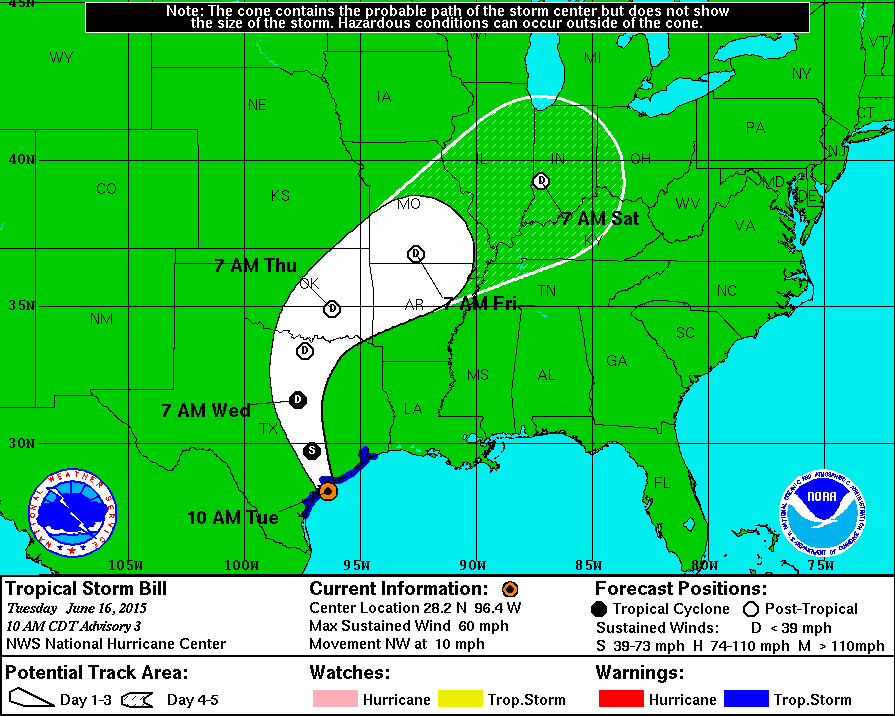
National Hurricane Center latest track on Tropical Storm Bill
DFW AIRPORT SETS RECORD FOR WETTEST MAY EVER
May 2015 is the wettest May ever on record for DFW with 16.96 inches of recorded rainfall, and it is also the third wettest month ever on record. Only April 1922 and April 1942 beats this month with 17.64 inches and 16.97 inches of rain respectively. It is also the wettest May in over 30 years. The last time we saw rain of this magnitude, during the month of May, was in 1982 when 13.66 inches of rain fell. The top four rainiest Mays are as follows:
1. 2015 – 16.96 inches
2. 1982 – 13.66 inches
3. 1957 – 12.64 inches
4. 1946 – 12.09 inches
VERY DANGEROUS SEVERE WEATHER SETUP TODAY AND TONIGHT
The Storm Prediction Center has upgraded our forecast area to a level 4 Moderate Risk for severe weather. All modes of severe weather will be possible, including a significant tornado threat. A Tornado Watch has already been posted for much of the forecast area. An eroding cap will give way to significant lift from an approaching dryline and large storm system lifting northeast onto the Central Plains from the Desert Southwest. Storms are already forming off the dryline and moving eastward just east of Abilene. A very moist atmosphere is in place across the area. There is 3000 to 4000 J/Kg for convective available potential energy (quite high) and moderate wind shear on the order of 300 M2/S2. Of real concern is backing surface winds across the area. All these parameters point to supercellular storm mode with any storm capable of producing large and strong tornadoes and giant sized hail up to softball/grapefruit size. In addition, heavy rainfall will be possible and some of the tornadoes could become rain wrapped and difficult to see. Residents of DFW should pay close attention to the changing weather conditions, and please take seriously any Tornado Warning issued for your area by taking appropriate action. Remember the best place to go is to an interior room, without windows, on the lowest level of the building or home.