Out of 117 years of weather records, dating back to September of 1898, DFW records its wettest year on record officially today. With 55.30 inches of rain (as of 8am on Friday, November 27, 2015) this shatters the old record of 53.54 inches set in 1991 with the month of December left to go.
Category Archives: News
3 TO 5 INCHES OF RAIN EXPECTED BY SUNDAY AT DFW MAKING FOR THE WETTEST YEAR ON RECORD
A very wet holiday weekend is in store for much of the area. In fact, we are expecting 3 to 5 inches of rain across the area by Sunday. If this forecast verifies, this will make 2015 the wettest year on record at DFW. Currently, DFW is the 3rd wettest year on record with 50.75 inches of rain officially recorded. Only 1991 (53.54 inches) and 1932 (51.03 inches) are wetter. Thus, DFW only needs to pick up 2.80 inches of rain to break the record. We should out do that by Sunday with December left to go!
A large upper-low will move down from the Pacific northwest and carve out a deep trough over the western CONUS. This upper-low will become cut-off from the mean flow and slowly migrate eastward over the holiday weekend. At the same time, the deep trough will allow cold, Canadian/Arctic air to spill southward. This cold airmass will be very shallow in nature and move southward via cold air damming processes along the lee of the Rockies into Texas against southwest flow aloft. The coldest air will become entrenched across West Texas where temperatures will plummet below freezing setting up for a period of icy weather this weekend. Strong southwest flow aloft will moderate the cold air as it moves into our area. Thus, temperatures are expected to stay above freezing leading to a cold rain event at DFW. The heaviest rains will occur ahead and along a strong cold front expected to plunge through the area Friday morning. PWATs (precipitable water) are expected to climb as high as 1.75 inches during this event, which is in the 99th percentile for November. In addition, additional moisture will be advected over Texas from the remnants of tropical cyclone Sandra in the Pacific basin. All this points to a heavy rain event across the area. We are not expecting severe weather or wintry precipitation with this event, at this time.
Moisture and warm air advection should intensify today and tonight and become strong enough for areas of drizzle or light rain this evening into tomorrow. An increase in clouds and temperatures through Thanksgiving Day will be possible as this process intensifies out ahead of a strong cold front barreling southward. Precipitation chances increase later on Thanksgiving Day as lift begins to encroach on the area as the cold front moves southward. Rain showers, heavy at times, and few claps of thunder will be possible out ahead of, along, and behind the front as it moves through the area. Additional rainfall will be possible on Saturday through Sunday as the dynamics arrive from the remnants of tropical cyclone Sandra. By Sunday, we should pick up 3 to 5 inches of rain across the area. The upper-low should be moving out east across the Plains pushing the trough out of the area ending all rain from west to east on Sunday/Sunday night.
DFW HAS ITS FIRST FREEZE OF THE 2015-2016 SEASON
Yesterday, officially, DFW Airport records its first freeze of the 2015-2016 season. The temperature reached 30°F for yesterday’s low. This effectively ends the growing season for the area.
POTENTIAL FIRST FREEZE/FROST THIS WEEKEND [UPDATED]
UPDATE: The latest data continues to deepen the cold air behind early Saturday morning’s strong cold front (as discussed below). The airmass behind this front is going to be continental Canadian with H85 0°C line now projected to reach as far south as the I-20 corridor. This should promote widespread light freezing conditions across the northern half of the forecast area by Sunday morning. As a result, temperatures have been lowered Saturday into Monday. Temperatures may actually stay in the 40s for much of the day on Saturday with blustery north winds up to 35 mph and struggle to reach 50°F on Sunday. Clear skies and lighter winds will promote excellent radiational cooling potential Sunday morning with lows north of I-20 around the freezing mark, including DFW Airport. The colder spots may dip into the upper 20s. This is a good time to start winterizing your homes and taking precautions for sensitive vegetation. This cold snap will likely end the growing season for much of the area. There may be periods of light rain or drizzle on Saturday morning behind the front, but with the Gulf remaining shut off, precipitation looks rather meager at best and amounts will certainly be light.
The long range models continue to waffle back-and-fourth in the extended. There still seems to be signs of the possibility of an Arctic air intrusion around or just after the holidays . . .
High pressure will build in behind the departing low pressure and Pacific cold front today. The pressure gradient will tighten today from the building anti-cyclone and departing low pressure causing west southwest winds to gust to around 30 mph this afternoon, making for a windy day. The winds should decouple after sunset and allow temperatures to fall into the 40s everywhere overnight. Winds should stay up just enough to prohibit fog formation. Temperatures should remain seasonable through the end of the week with lows in the 40s and highs in the upper 60s to around 70°F, which is somewhat typical for this time of year (maybe a little warm on highs).
A stronger cold front is expected to arrive Saturday. Gulf moisture looks to remain cutoff from this front, so precipitation looks minimal. However, a very chilly airmass will advect in behind this front with H85 temps approaching 0°C. This will allow temperatures to plummet into the 30s area wide by Sunday and Monday mornings with highs only in the 50s. This will likely set the stage for the first frost of the season for the DFW Metroplex. Most likely, the cooler spots outside the urban heat island may even experience a light freeze. The average first freeze for DFW is November 22nd.
There are signs, and the ECMWF has been hinting at this for several runs, that the Arctic may open up just in time for the Thanksgiving holidays. The EPO (Eastern Pacific Oscillation) is projected to turn negative which is an indication of troughing across the central/eastern CONUS. The ECMWF continues to build an Arctic airmass in British Columbia and Northwest Territories seeding it from cross polar flow from Siberia. Then, spills this southward into the Plains and eastward over the holiday weekend or just after. The GFS has also shown some signs of this in the past several runs, however, the latest 0z run does not show this at all. This could be a very interesting thing to watch over the coming days . . .
OUR NEXT STORM SYSTEM APPROACHES
DFW is bracing itself for another round of rain, some of which could become heavy, especially very early Tuesday morning.
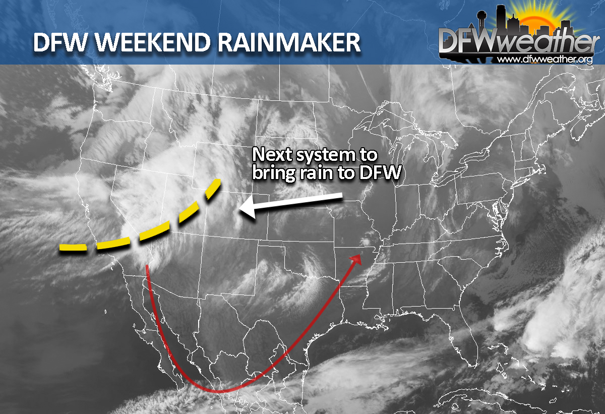
For Today (Saturday), a disturbance in the mid-levels of the atmosphere will be approaching from the southwest. This disturbance is already responsible for some convection upstream in the Trans-Pecos region. As it moves toward North Texas, it will help saturate the mid-levels of the atmosphere. However, it will be encountering increasingly drier air across our region, especially at the surface where dewpoints will largely remain below 50°F. As a result, think that any precipitation that forms will largely fall in the form of virga, rain that evaporates before reaching the ground. This will play havoc on high temperatures today. I think DFW will have a chance to warm into the 60s as the effects of the disturbance may not arrive in time to offset diurnal warming. However, the further southwest one goes, temperatures may be affected and some areas may fail to get out of the 50s today. The official forecast will call for occasional sprinkles today across DFW, maybe increasing to light rain tonight as the lower levels saturate. Rain amounts in general should stay at or less than 1/10 of an inch.
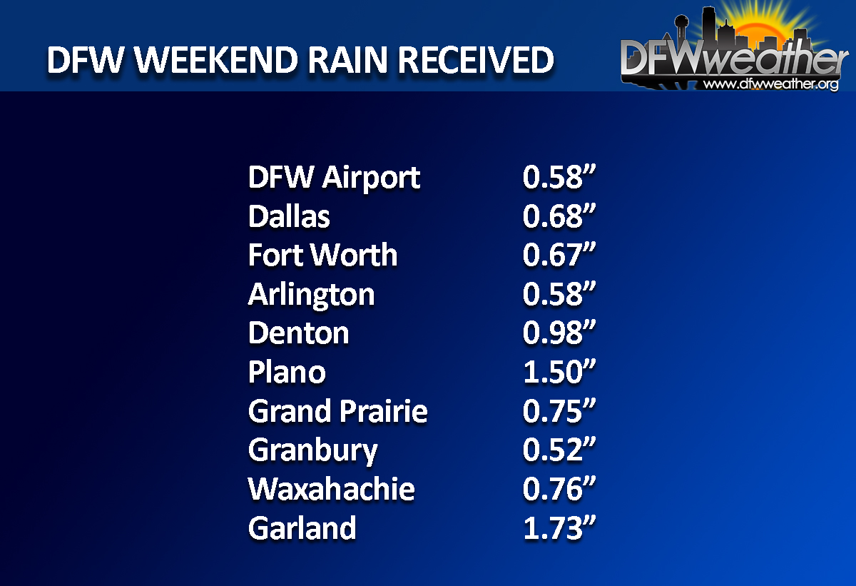
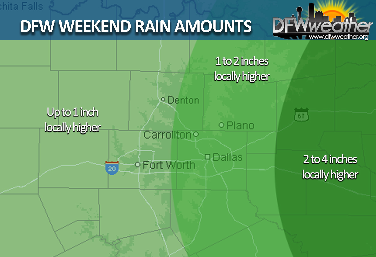
There should be a reprieve in any precipitation early Sunday morning as we await the dynamics from the approaching trough and strong upper-air disturbance. Rain should gradually increase from west to east Sunday as the system approaches. By Monday afternoon shear and instability increases and there could be a stronger storm or two. PWATs will also increase substantially by Monday night, as a squall line begins to take shape along a dryline/Pacific cold front racing fast across Texas. Some strong to possibly severe storms will be possible with this system, the main threats being from heavy rain due to higher PWATs, straight line winds, and possibly a spin-up or two. The squall line is not expected to reach the Metroplex to around daybreak Tuesday morning, thus the morning commute could be a wet one. The dryline/Pacific cold front pushes through Tuesday morning, thus I expect all of the storms to be east of DFW by 8:00 am ending all precipitation chances. The pressure gradient will tighten between the building anti-cyclone behind the front and departing low pressure system making for another windy day on Tuesday. Winds could gust in the 30 to 40 mph range. Seasonable weather will ensue the remainder of the week. Though I will stress nothing out of the ordinary by any standards, so expect temperatures to remain at or above normal for November. Early indications are that we could pick up 1 to 2 inches of rain by Tuesday.
Another cold front and system will bring the next chance at showers and thunderstorms by next weekend.
FORECAST UPDATE: STORM THREAT DIMINISHES – DRYLINE THROUGH MUCH OF THE METROPLEX
Today’s thunderstorm chances are rapidly diminishing as storms march eastward along with the dryline and cold front close behind. Strong, westerly, downsloping winds are increasing behind the dryline as the low pressure system deepens as it marches eastward across the central Plains. These strong downsloping winds will help temperatures soar to near record levels today. The record high temperature for today at DFW is 85°F set in 1911. Forecast highs were raised a bit after temperatures soared to the forecasted high of 83°F from this morning’s issuance. Winds will gust to near 35 mph behind the dryline making for a quite windy afternoon. Our winds will switch to the northwest this evening where they should decouple a bit after sunset. The much drier air will allow temperatures to cool efficiently this evening with overnight lows expected in the 40s area wide. We should be much cooler tomorrow with highs only reaching the mid to upper 60s.
We are still watching a southern stream system that could affect our weather as early as Saturday night with more chances of showers and thunderstorms, especially on Sunday and Monday. An even stronger system may be on tap for later next week.
AN ACTIVE PATTERN CONTINUES FOR DFW
A rather active weather pattern will continue through this week for DFW. Our next system to affect the area will arrive on Wednesday in the form of a Pacific cold front. The low pressure associated with this system will eject from the four corners region onto the Central Plains rather quickly. Scattered showers and a few thunderstorms will be able to form in the warm air advection pattern out ahead of this system as early as Tuesday night. However, our best chances for rain will come Wednesday morning with the passage of the cold front. At this time, given the timing of this system, speed, and lack of instability aloft, severe weather is not expected for the immediate DFW Metroplex. Rain amounts will be rather limited as well given the speed of the system. Winds behind the cold front will be quite strong bringing much drier air into the region. Winds could gust in the 30 to 40 mph range on Wednesday afternoon. The cool air associated with this frontal passage will not actually truly be felt until Wednesday night into Thursday morning where overnight lows will drop into the low to mid 40s area wide.
Another system will approach the area by next weekend brining our next bout of rain, especially on Sunday. This system may become detached from the mean flow and be a less progressive system.
There is still no indication of any truly cold air or freezes coming our way, at least not in the next ten days.
LATEST ON RECORD FOR DFW AIRPORT TO FALL BELOW 50°F
As of today, November 5, 2015, DFW has failed to fall below 50°F. We will finally do so Sunday and Monday mornings, possibly as early as Saturday morning. This will make it the latest we have ever gone without falling below 50°F over 117 years of weather records (dating back to 1898).
HEAVY RAIN POSSIBLE ON THURSDAY…LOWS IN THE 40s THIS WEEKEND
Our next storm system, that will affect our weather, is currently moving from down from the Pacific northwest. It will move as far south as Nevada before opening up and moving east across the Plains. Ahead of the upper-low, moisture will begin advecting into our area, indicative of the mostly cloudy skies today. Showers and thunderstorms will begin to overspread the area as early as tonight and become widespread on Thursday into Thursday night. There is some marginal instability with this system and very high shear, thus we cannot rule out one or two severe storms with moderately sized hail, but overall widespread severe weather is not expected with this system. However, PWATs are expected to climb to 2 inches by Thursday. This will allow for storms to produce heavy rainfall. So by far our biggest threat with this system will be heavy rainfall. Since our grounds are saturated and cannot hold anymore water, the National Weather Service in Fort Worth has already issued a Flash Flood Watch for nearly the entire forecast area. Widespread 1 to 2 inches look like a good bet with this system with isolated higher amounts.
A cold front will move across the area behind this system early Friday. This front will bring a little chill to the air as it has some Canadian air behind it. Thus, morning low temperatures are likely to dip into the 40s for the first time this year at DFW Airport over the weekend with highs struggling to make it into the 60s on Sunday. The models continue to hang back some energy for the weekend. Thus, after a dry day on Friday, low end POPs are warranted for Friday night into Saturday for some light rain in the cooler air.
We are watching another storm system for early next week that has the potential to bring more showers and thunderstorms to DFW. A stronger cold front may be on tap for later next week.
OCTOBER 2015 THE 2ND WETTEST OCTOBER ON RECORD
October 2015 has come in as the second wettest October on record. The top five wettest Octobers are:
- 1981 – 14.18 inches
- 2015 – 9.82 inches
- 1919 – 9.44 inches
- 1991 – 9.32 inches
- 1959 – 9.22 inches
This brings the total for the year 2015 to 48.93 inches of precipitation, making it, so far, the sixth wettest year in DFW weather records.
October 2015 came in with a mean average temperature of 71.2°F, making it the 12th hottest October on record. This puts the year 2015 so far in the running, with an annual average mean temperature of 69.3°F, as being the hottest year on record for DFW.