
Another record high was broken yesterday, November 4, 2017 at DFW Airport. The temperature reached 90°F breaking the old record of 88°F set in 1987. The record heat will continue today as a combination of downslope flow, compressional warming from an approaching cold front, and upper ridging will aide in allowing temperatures to soar out of control. The record for November 5 at DFW is 89°F set in 2005, but will easily be broken as the forecast calls for a high of 92°F. This record November heat (90+ degree temperatures in November) is exceptionally rare, and nothing like it will likely be experienced again during our lifetimes. A weak cold front will move across the area tomorrow and stall around the I-20 corridor, but will get reinforced and pushed out of the area as a stronger cold front arrives on Tuesday. This will set the stage for an overrunning rain event Tuesday night through Wednesday night. Temperatures will cool dramatically behind the Tuesday cool front with highs on Wednesday remaining in the 50s.
Category Archives: Historical
DFW SHATTERS HIGH TEMPERATURE RECORDS
A record high temperature of 94°F was set at DFW Airport yesterday, November 2, 2017. This shatters the old daily record of 87°F set in 2012. In addition, this also breaks the record of the hottest temperature ever recorded during the month of November. The old monthly record was 89°F set on November 5, 2005. This also is the hottest temperature ever recorded at DFW so late in the year.
ALL TIME NOVEMBER RECORD HEAT EXPECTED TOMORROW AT DFW
Temperatures are expected to soar into the 90s for portions of the forecast area tomorrow. Current forecast temperature at DFW Airport for tomorrow is 91°F. If this occurs, it will be the hottest temperature ever recorded for November and the hottest temperature ever recorded so late in the year. A dryline will sharpen out west and surge eastward bisecting the forecast area. Areas behind the dryline will experience a drop in humidity, strong southwesterly winds, and soaring temperatures. Since the recent bout for freezing temperatures, fuels have dried and cured. Combined with the low humidity and strong southwesterly winds, conditions will become critical for the starting and spreading of grass fires. Thus, an elevated fire weather risk will be possible the further west you go from the dryline. Areas east of the dryline will have higher humidity levels and temperatures will be held in the 80s.
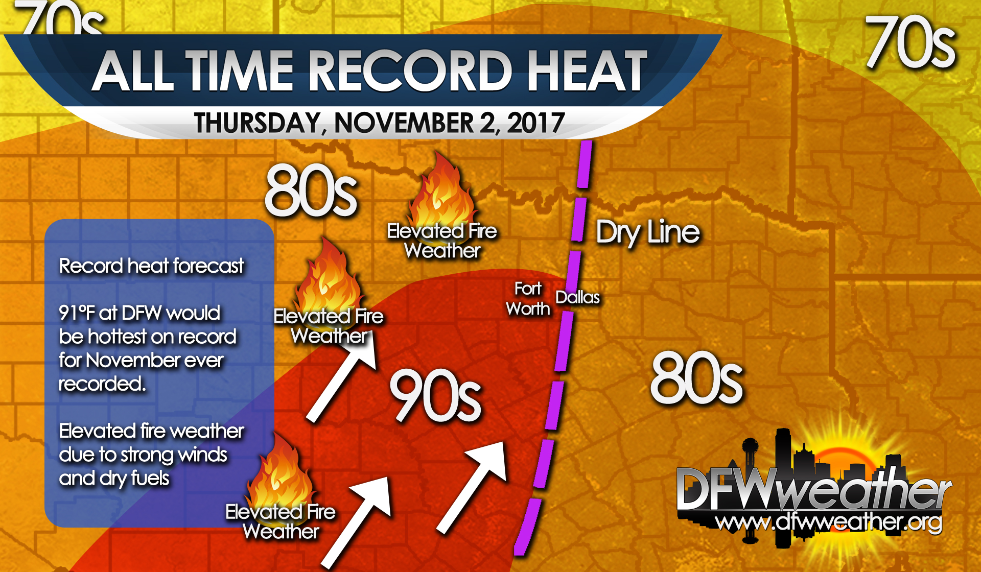
Forecast high temperatures for Thursday, November 2, 2017.
IT IS THE COLDEST OCTOBER MORNING SINCE 1993 AT DFW
After an Arctic cold front blasted through the area early yesterday morning, it has been downright cold around DFW. This morning the temperature dropped to 34°F officially at DFW Airport. This makes this the coldest October morning since October 31, 1993 when the mercury hit 29°F with, believe it or not, a few snow flurries during that cold air outbreak. It also is the coldest we have been at DFW since January 27th of this year. Last year was the hottest winter on record for DFW, even though the coldest temperature of the winter did get to 14°F on January 7th. The prior winter (2015-2016) was also one of the warmest on record and had the warmest low ever recorded during a winter season of only 27°F. Here are some other low temperatures this morning from across the area:
- Fort Worth Alliance 27°F
- Fort Worth Meacham 35°F
- Fort Worth Spinks 28°F
- Arlington 29°F
- Dallas Love Field 34°F
- Denton 28°F
- Granbury 29°F
- Cleburne 28°F
- Decatur 32°F
- Grand Prairie 37°F
- Midlothian/Waxahatchie 31°F
100 YEAR RECORD RAINFALL BROKEN YESTERDAY AND DFW OFFICIALLY REACHED 100°F FOR THE FIRST TIME THIS SUMMER LAST FRIDAY
Last Friday, June 23, 2017, DFW Airport’s high temperature hit 100°F for the first time this summer, thanks to compressional warming ahead of a rather strong late season cold front. This front was responsible for the overnight intense convection that occurred Friday night. By the end of the day Saturday, June 24, 2017, DFW broke a 100 year rainfall record. 3.84 inches of rain officially fell yesterday shattering the old record of 1.76 inches set in 1917. This brings the monthly June total of rainfall for 2017 to 7.93 inches.
A COOL START TO MAY 24, 2017 AROUND THE AREA
Some of the coldest temperatures (so late in the month of May) in many years recorded across the area this morning (May 24, 2017). Officially, no record was broken at DFW Airport. The record still stands at 54°F set in 1940. The official low this morning was 58°F at DFW Airport. Below are some of the low temperatures around the forecast area this morning:
Granbury: 49°F
Decatur: 50°F
Denton: 50°F
Dallas: 56°F
Arlington: 55°F
Fort Worth: 55°F
DFW Airport: 58°F (official)
We probably will not see readings again this cool until next fall!
RECORD HIGH SET YESTERDAY, MARCH 20, 2017 AT DFW AIRPORT
A record high of 92°F was set yesterday at DFW Airport. This breaks the old record of 91°F set in 1932. The record for today, March 21st, is 100°F and will not be achieved as highs are forecasted to stay about like yesterday around 90°F.
IT’S OFFICIAL – 2016-2017 HOTTEST WINTER ON RECORD FOR DFW
Now that meteorological winter has ended (December through February), it is official that 2016-2017 is the hottest winter on record for DFW with an average temperature of 53.8°F.
February 2017 is also the hottest February on record for DFW with an average temperature of 60.6°F some 10.7°F above normal.
In addition, the winter of 2016-2017 also set a record of 80°F+ degree days in a given winter with 14 days of temperatures at or above 80°F.
Technically, we can still experience freezing temperatures through mid April, but so far 2016-2017 has the lowest number of recorded freezes in a cold season with only 11 days. Freezes are actually measured from October through April. This is 3 days fewer than the lowest prior record of 14 freezes set in several winters.
Below are the top five years of the above records:
Top 5 Hottest Winters:
- 2016-2017 – 53.8°F
- 1999-2000 – 53.1°F
- 1906-1907 – 52.9°F
- 1951-1952 – 52.8°F
- 1931-1932 – 52.0°F
Top 5 Hottest Februarys:
- 2017 – 60.6°F
- 1976 – 58.4°F
- 1930 – 57.6°F
- 2000 – 57.3°F
- 1932 – 56.8°F
Top 5 Winters with the Most 80+ Degree Days
- 2016-2017 – 14 days
- 2005-2006 – 10 days
- 1908-1909 – 10 days
- 1995-1996 – 9 days
- 1951-1952 – 8 days
Top 5 Fewest 32-Degree Days in a Cold Season:
- 2016-2017 – 11 freezes*
- 2011-2012 – 14 freezes
- 1999-2000 – 14 freezes
- 1931-32 – 14 freezes
- 1930-1931 -14 freezes
*Could still change as we can technically still reach freezing until about mid-April.
DFW SETS ANOTHER RECORD HIGH YESTERDAY, FEBRUARY 23, 2017 / 2017 HOTTEST FEBRUARY / 2016-17 HOTTEST WINTER
DFW high temperature yesterday, officially at DFW Airport, was 88°F. This breaks the old record of 86°F set in 1933.
This also adds to the record number of 80+ degree days set in any winter. 2016-2017 is the winter with the most 80+ degree days currently at 12. The old record was 10 set in the 2005-2006 and 1908-1909 winter seasons.
*February, with only 4 days left in the month, is on target to be the hottest February in DFW history with an average mean temperature so far of 60.7°F. This shatters the old record of 58.4°F set in 1976.
*The winter of 2016-2017 is also set to be the hottest winter on record for DFW (as measured December 1st through February 28th) with a mean average temperature of 53.9°F. This breaks the old record of 53.1°F set in the 1999-2000 winter.
* Given the forecast through the end of February, these statistics will likely hold, but the final averages may change slightly.
RECORD HIGH TIED YESTERDAY JANUARY 10, 2017 AT DFW
The record of 79°F set in 1995 was tied yesterday, January 10, 2017, at DFW Airport. The high temperature reached 79°F yesterday afternoon, despite a weak cold front moving through the area. That front will retreat north today putting us back in the warm sector again today. High temperatures today will be flirting in record territory. The record for January 11th is 83°F set in 1911, and the forecasted high is 81°F.